We’d been driving through the desert highway which ran parallel to, and high above, the course of the Indus. The undulating landscape around the highway was carved out of a soft but rocky soil. I found later that the river has been moving soil around the plateau for 10-20 million years, and this aspic made of soil and rock is called the Indus molasse basin. The phrase “lunar landscape” was invented by an unknown hack as an utterly wrong description for this riverine landscape. Millions of tourists now repeat it unthinkingly, because the land does not look green and fertile. But the word for a desert is desert.
Like in any desert there are plants which grow here. There are insect communities which they sustain. There are lizards and spiders which prey on the insects. And there are, very visibly, birds which prey on the predators. During the drive my eye adapted quickly to spotting clumps of grass or plants huddled low to avoid the wind. The altitude means that the air is thin, and the UV levels are high. The resulting glare plays games with your sight, and distinguishing green from the khaki landscape may be hard, unless you have grown up in the hot dusty plains of northern India.
As a result I managed to spot these flowers as we sped by. Nassir Khan, our guide and driver for the day, stepped on the brakes immediately, and I had only a short walk up a slope to where the plant was growing out of a clod of earth. This was a globe thistle for sure. We were at a height of above 3000 m, and considering that we were in Ladakh, this was almost certainly the Himalayan blue globe thistle (Echinops cornigerus). The appearance of the bracts, the flowers, the stems, and the leaves are all consistent with this identification.
But the literature is rife with confusion between E. cornigerus and the snow-white globe thistle (Echinops niveus), perhaps half of it due to amateurs like me. Typically the confusion occurs at lower altitudes, where E. niveus (or even the low-altitude, Indian globe thistle, Echinops echinatus) is mistaken for its high altitude cousin. It is often said that E. niveus is found to a height of 1700 meters in Kashmir, Himachal Pradesh, Uttarakhand and Nepal. But that altitudinal ceiling was only reported in the early 1980s from sites in western Nepal. With warming weathers, and ever increasing traffic, it is not impossible that it has spread its range along this road, the Srinagar-Leh highway. Instead of adding to the confusion, let me keep the issue open until clinching evidence emerges, with the proviso that this is more likely to be Echinops cornigerus.
Weather can change very quickly in the mountains. We had driven down the valley of the river Shyok in a happy sunlit mood. As we started back after lunch in Turtuk, clouds had blown in from the west and the light had turned sombre. The name of the river means death in languages that derive from old Tibetan, and in this dim light it was not hard to make that connection.
The road was smooth most of the way, and The Family nodded off after the heavy meal. Yasin, our guide and driver, was intent on the drive. We’d rolled the windows down and he’d switched off the music so that we could listen to the water and the weather. I was in my groove right now, having put away my favourite camera to utilize the wider angle shots of the landscape that my phone gives. I realize that I could tell the story of the drive back in many ways: as a road trip, as a journey using the metaphor of the Bardo Thodrol (the Antarbhava Nivarna, known in the west as the Book of the Dead), or even as a photo gallery interspersed with technical comments by the photographer.
But the telling that appeals to me are the questions that rose in my mind as I looked out, and the answers that I found later. This land raised profound questions about our place on earth, and figured in a controversy that preceded the writing of the IPCC’s fifth report in 2014. But before I tell you about it, let me give you an impression of the landform that piqued my curiosity. Even though the muddy river was at its widest in summer, when we drove along it, the valley it flowed through was very much broader. The two-lane road seemed to be on a plain, and there was enough flat land around it that the road could have had four lanes through much of the valley. I’d never seen this in a mountain stream before.
Another remarkable feature was the profusion of loose rock and pebbles, some jagged, as if a scree had spilled down slope, others completely rounded as if by the action of water and glacier over millennia. A further enigma was visible in the sand dunes and mud flows that were could be seen at places along the river. This is a special mystery because the land has very little rain: no more than a 100 mm in a year. The patterns of erosion are not due to rain.
What a curious tourist like me sees is a very small part of the questions that arise in the mind of a geologist who walks through this landscape. So all my questions, and more, are answered in the extensive geological literature that is easily available these days. The answer lies in a dynamic and fluctuating history of glaciers and ice dams in the last 150 thousand years in this region. An early study counted over 2000 glaciers active in the upper Shyok valley, which were highly dynamic, receding and expanding rapidly, but whose extent had not changed significantly between 1973 and 2011.
When this paper was published as the 5th IPCC report was being drafted, it gave rise to an immediate controversy about global warming. If glaciers had not melted in the Himalayas, as they had in the Alps, then how could the latter be due to anthropogenic warming? An old friend was involved in the group that found the answer: Himalayan glaciers are mostly rock covered, unlike the open glaciers of the Alps, and it is the thinning of the ice layer under the scree that reveals the extent of melting. Their ground surveys revealed that glaciers here were melting as quickly as Alpine ice flows. Further studies confirmed this, and the IPCC’s AR5 report had a chapter on this topic which reported this as the consensus of scientific opinion.
We passed one of the largest tributaries of the Shyok in this stretch. I had looked down the other valley on our way west in the morning and had a glimpse of the high peaks of the Karakoram range. Even in this light I could see an ice-covered peak as we sped by. In the upper reaches of the Shyok river, after it descends from the Rimo glacier and flows south, the river marks the geological suture between Ladakh and the Karakoram. In the stretch that we drove through, the river had turned north and west, and again come close to the Karakoram range. I can’t figure out from maps which river descended from the Karakoram to join the Shyok so far in the west.
We’d switched between the left and right banks a few times over bridges, most in good repair. The exception allowed a single vehicle to cross at a time. Waiting for our turn in the small queue, I’d told The Family how these crossing were once considered treacherous. The many caravans which were washed away in this stretch of the silk route gave the the river its name, Shyok, the river of death. But these summer floods were seldom caused by rain. They were more often due to the melting of ice dams which had formed over winters. Some ice dams can last quite long, and collect sedimentary deposits, some of which I’d seen exposed during the day. The failure of these ice dams cause enormous floods and quick erosion. This is also perhaps the reason for the wide river valley we saw.
As we approached the Hunder-Diskit area, the clouds opened up, and dappled sunlight streaked the mountain sides. In this place farming and irrigation is transforming the land. The forest department is busy planting cypress in a bid to green this land, forgetting, as it has since colonial times, that introducing an exotic species leads to catastrophe a few decades on. But you cannot fault the locals for turning to agriculture this wide fluvial-lacustrine valley fill, created by the ancient ice dams. Human sympathy is due when impoverished people try to better their own lot through historically tested means such as agriculture. However, it seems that corporations and bureaucracy which follow any such expansion of human activity create changes inimical to the human world. Is this Gaia at work?
We’d spent our days in Leh looking for a good place which serves Ladakhi food. The usual social networks for tourists directed us to a popular place which served ddishes known in cities, some Tibetan, others not. The town was full of cafes and bakeries, and generic Indian food. We asked the dependable Mr. Kanlon, and he had an immediate answer: Namza. So we went there for our last lunch in Leh.
From outside it looked like a regular house. But when we passed the front door it opened into a kitchen garden, an urban farm if you wish. A wood and glass cabin was the dining area, perhaps eight tables, bright and cheerful in the afternoon light. The menu spoke of fresh ingredients from the local market and from the garden. We looked out: potato, tomato, beans, pak choy, were in evidence. One of the wait staff pointed out local herbs.
We turned to the menu. After ten days of looking at the wildflowers of Ladakh, I was beginning to wonder how much of it found its way into the kitchen. Often a lot of local plants go into food, but they are not considered to be suitable for guests. As a result, many of these interesting tastes drop out of restaurant menus. So I was happy to see that a nettle soup appeared on the menu. The soups all sounded very interesting, but I settled for the nettles because I wasn’t likely to taste this ingredient elsewhere. I’d not seen much in the way of meat in the local food, so it was interesting to see that they made sausages in house. That was clearly something else to try.
The Family had ordered khambir (the Ladakhi yeasty naan) with an yogurt dip which arrived at the table rather quickly. I shared a bit of it, but I held back, because I suspected that I’d over-ordered. The nettle soup had bits of soft chhurpi (the yak-milk cheese of these heights) and slivers of chicken in the broth. The sausages were redolent of herbs. All I needed after that was a dessert, but Ladakh does not really do desserts. There were stewed apricots on offer, and I took it (that’s the featured photo). It was perfect, just plain local apricot freshly stewed without additives.
Scree covered slopes slid by outside the windows of the car as we came down from Khardung La. In the last few days I’d become better at spotting vegetation in this seemingly bare landscape. When I saw a tiny clump growing on a rock, I stopped the car and walked back to look at it more closely. The plant was new to me. In this thin air, at an altitude of about 5 Kms above sea level, I did not want to scramble up slope to smell the flowers and leaves. Instead I took photos.
A few days ago I would have been sceptical of tales of vegetation at these altitudes. But I’d been seeing too many birds at this height to dismiss the idea out of hand. There were corvids here, and they feed on small animals, lizards and rats, or large insects. Insects would need vegetation of some kind. Perhaps the smallest could live on lichens and moss, but anything which could feed a crow-sized bird would probably need plants. Still, it was strange to see a clump of vegetation on a single exposed rock.
A closer look revealed a shallow covering of soil in a little depression on the exposed face of the rock. The temperature was under 10 Celcius, perhaps around 7 Celcius, and the soil looked utterly dry and crumbly. I later found that the soil at this height, and in this season, holds less than 5% of its weight in moisture. This was a plant of a cold desert, adapted to extremely high ultraviolet light and extreme daily temperature fluctuations. I wondered whether its roots held on to cracks in the rock. With the wind here, it must be holding on to more than the thin soil. The roots apparently spread quickly to extend the area covered by the clump. But how did it get here? Did a seed drop here by chance, or did a bit of a twig with root blow into this island of soil? And was it wind that blew it here, or was it carried by a bird?
I’m not good with temperate or cold climate plants. It took me a while to figure that this could be a catmint. Perhaps if I’d smelled the leaves and flowers I might have come to mint (family Lamiaceae) earlier. From catmint it was a short search to find that this is Nepeta longibracteata, the long-bracted catmint found in Tajikistan, Afghanistan, Himalayan and trans-Himalayan India and Pakistan, and Xinjiang in China. The flowers grow from purple bracts, and have the trumpet shape and spots which seem to be characteristic of catmints. The perennial plant is apparently common across this region, although I saw it only this once. I found later that it yields an aromatic oil which is used locally. I’m sure I’ll not forget this plant if I come across it later: the leaves, bracts, and flowers are all very recognizable.
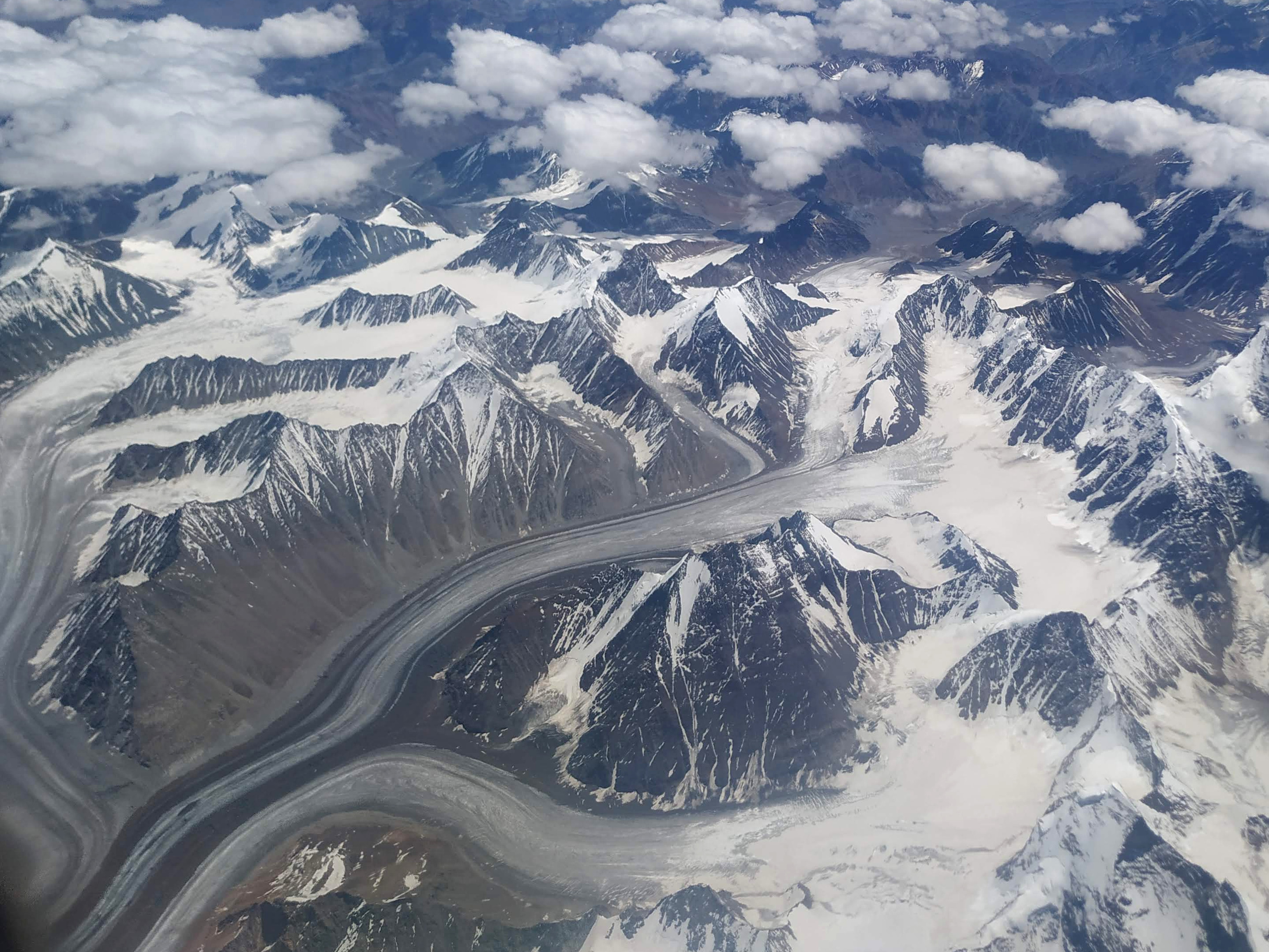
Home of clouds, the Himalayas have a very appropriate name. The mountains jut up into the sky above the weather, stopping even that huge global circulation which we ground-huggers see as the Indian Ocean monsoon. And what are the Himalayas but the immense, long drawn out collision of two continental plates. As the Indian plate sped northeast across the world, wheeling westwards, a ten million year collision raised these mountains and prised the Tibetan highland into the air from the mass of the Asian plate. About then, elsewhere, a plume of magma rose from the earth’s core and created the enormous African rift valley, setting into motion the changes that started a branch of apes to begin walking across the world. Now, a tube of aluminium filled with those same apes followed a high arc across the home of clouds.
Sitting in that crowded tube, I Iooked out over the shoulder of The Family at the monsoon cloudscape that passed below us. Abruptly I realized that some of the white was not the fluffiness of clouds. A closer look told me that we had left the lowlands behind and reached the high Himalayas. Below us was a rugged, folded landscape, where streams and earthquakes had carved valleys and raised peaks. This late in July the snow line lies above 5.5 Kms. So the peaks we saw were at least 6 Kms high. This is where weather stops.
In the next ten minutes we passed over heights that I would certainly never have reached on foot: a land of eternal snow. Few animals come this high. Among all the world’s migratory birds, only bar headed geese (Anser indicus) fly over these mountains. Coincidentally, we were flying parallel to one of their migration routes, the one they follow as they move between their wintering grounds north of Mumbai, and their summer breeding grounds in Ladakh’s Tso Moriri, west of Leh.
The landscape below us was amazing. Multiple glaciers flowed away from a huge snowfield. I wondered what it would be like to stand on one of those promontories below us and look down on the icefalls that I could see. The air inside the plane suddenly felt hot and stale as I imagined the bitter cold wind below, blowing loose snow over the ice fields. Sadly I was seeing these views as the last of the snow melts from these mountains. Even ten years ago, I would not have seen so much exposed brown below me.
And then we had crossed from one tectonic plate to another. Below us was another climatic zone, one where the monsoon did not reach. Wisps of cumulus floated over the bare brown land. From this height I could see many lakes dotted over the land, large and small. With the extremely low precipitation that this high desert gets, the lakes must be all fed by snow melt. As the earth heats up and the last snow melts, I wonder what will be the fate of the ecologies that depend on these lakes: the bar headed geese, the black necked cranes, snow pigeons, snow leopards, snow foxes, blue sheep, the cold-adapted vegetation of these lakes, and the many insects which live only here. Distance from the ground lets you think these thoughts.
Before I expected it, we begin our descent. Voices come over the PA giving the usual safety instructions. As we approach the ground I see the play of light and shadow over the bare desert which will be our home for the next one and a half weeks. I’m excited. I look at The Family, and she says, “Finally. I’ve been waiting to come here for years.” Below us we see a green valley, probably a sign of humans: the water from a stream used to grow the crops and trees that we like to have around us. We carry with us memories of ancestral landscapes and we try to reproduce them wherever we settle.
Before I have to put away my phone, I see us approach the town of Leh. Like every overgrown human settlement, this spills out from the valley where it was born, into its surroundings. Humans metastasize. That magma plume below the Afar depression which shattered the African continental plate 40 million years ago set into motion large changes on the surface of the planet.
After every museum and monastery closes for the evening, tourists descend on Leh’s main market. It’s not a small number of people, I even bumped into acquaintances from work at the market. The Family decided to go there a little before ravenous hordes descend on the cafes. Her first photo of the day shows an exotic market scene: a row of vegetable vendors against a backdrop of beautiful carpets, and a scattered few shoppers. Even the vegetables are laid out on lovely carpets. It is the best photo of the market I’ve seen, but it’s not the typical photo.
If you want the typical photo, that’s this. Crowds of tourists not sure what they want to do. Some sit on benches, others take selfies or photos of each other, the rest cruise in gangs up and down the drag, while the more clear-headed fill up the many cafes and bakeries which offer free wifi.
The market has one of the most cheerful post offices I’ve seen anywhere. It was closed, of course, by the time I spotted it. But there was always a gaggle of tourists around it, either taking selfies against the “I Love Ladakh” mural on one wall, or using it as a meeting point. The bright white building with red trim looked like it might be a place where locals meet and chat.
There were two beautiful mosques on the road, in two different styles. One was an exotic plaster and wood structure: all white and light wood stain. I had to look twice to see that it was a mosque. The architecture was adapted from the native Ladakhi style: the grand gate was in intricately carved wood. The other was a structure that was more immediately recognizable, the turrets and doors, the green and white colour scheme, similar to the mosques that you see around the world. About half of the native Ladakhis are Muslim, the other half Buddhist. This is an ancient history. Ladakh was on the old silk route, and cultures and religions traveled along it for much more than a thousand years.
I liked the view along the drag: with the Leh Palace perched on a hill visible along its axis. The afternoon had turned cloudy, but now, at sunset the clouds parted and we had this joyful golden light on the palace and the upper stories of the shops here. I left The Family to find old Ladakhi jewelery in jade and coral and climbed to a cafe on one of the upper floors with my copy of Gurnah’s “The Last Gift.”
A couple of days earlier The Family had discovered the wonderful Ladakhi apricots: small, juicy, and flavourful. She’d bought a kilo from this lady, and we ate them over a few days. We picked up the fruits again later, and they would be one of the best things we got back from Ladakh.
And the local jewelry? Glad you asked. They are jade and coral, set in silver. The silver-work was fascinating. I saw three pieces, one was antique, the second was a grand old silver piece with new jade and coral pieces added to it, and the third was an old coral set with new rings of silver added to it. In this last one, the silver will get a little patina as it ages.
Eeny, meeny, miny, moe, Catch a tiger by the toe. If he hollers, let him go, Eeny, meeny, miny, moe.
Children’s rhyme
A mural in the Leh palace shows a hunter armed with a spear and a bow and arrows hunting a tiger. The figure of the hunter hiding behind a Jacaranda tree can still be seen. The tiger has almost disappeared. Life copies art?
On the walls of the main shrine inside the Hemis monastery are paintings in the usual Tibetan Vajrayana Buddhist iconography. The first was a painting of the three powerful deities who helped Guru Padmasambhava to pacify the demons who were troubling the mountain kingdom. The most powerful of them was the central figure of the Yamantaka. I’m not an expert in this iconography, but I could tell him by the water buffalo which he rides (the buffalo seems to be somewhat weighed down by him). All these pictures are meant to educate, so they designed to be easy to interpret.
Detail of the painting of Yamantaka
The Yamantaka is often shown as devouring a snake, which denotes time. This is a symbol which emphasizes that he conquers time, and illustrates the meaning of his name, the conqueror of death (Yamantaka = Yama + antaka in Sanskrit). Here he holds a snake in two hands. Interestingly, he is the aggressive aspect of Manjusri, the Bodhisattva of learning and wisdom. That’s a bit esoteric, but it is meant to show people how to conquer death.
Painting of Shridevi, known in Tibet as Palden Lhamo
I should have taken photos of all three of these deities, but I only have this other photo of the painting which shows the wrathful aspect of Palden Lhamo (whose name in Sanskrit is Shridevi). She has many aspects as a guardian diety, and again, one of her attributes is wisdom and learning. Hemis monastery belongs to the Red Hat school, so she is given a secondary role. In the Yellow Hat (Gelug) school she might have had the central role.
While recovering from a very minor surgery in hospital, I looked out over the top of a Jamun (Syzygium cumini) tree. Jamun is one of the fastest growing trees of India. In about 6-8 years it grows to a height of about 10 meters, and it lives for about a 100 years. It begins to fruit when it is about 8 years old, and continues to yield a good crop until it is well over 60. I love this fruit, and look forward to the hot time of the year for it. The tree is hardy and grows well enough to be considered invasive in some parts of the world. If you are interested in carbon mitigation through planting trees, this should be a great choice. But how much carbon does it bind?
A decade old tree is about a meter in perimeter, which means that with a height of 10 meters, its volume is 10/(4π) meter3, which is about 0.8 meter3. Jamun is one of the denser woods, with a specific gravity of 0.7. This means that a 10 meter tall tree weighs about half a metric ton. About half the weight of the wood would be carbon (the rest is essentially hydrogen, oxygen and nitrogen). Planting about twelve billion new jamun trees would be sufficient to capture the carbon that India emits in a year, for every year in the next decade or so.
Typically a jamun orchard will have a spacing of about 10 meters between trees. This means that one tree is usually planted in about 100 meter2 of area, which is about 10,000 every km2. India has an area of 3.2 million km2. So planting enough Jamun trees to capture the carbon that we emit would take about 12% of India’s land area. This is a little larger than the area of France. However, this will have to be well drained loamy soil, with sufficient water. That would be about one fifth of the agricultural land in the country.
It already sounds pretty hard. But then I found that an increase in tree cover by 2261 kilometer2 in two years was considered celebratory news. This, as you can see from the numbers above, is the area needed for about 0.02% (1 out of every 5000) of the trees one needs to plant! Maybe that means that planting enough trees to mitigate carbon emission is in the realm of pipe dreams. I’ve talked about a fast growing tree, because it would absorb carbon fast. If we take slower growing trees like teak or pine, then we would need to plant more of them to absorb carbon at the same rate.
Trees are good. Trees are healthy. Trees allow other vegetation to grow beneath it. Trees are needed to slowly suck the carbon out of the air. But today’s meditation convinces me that planting trees is no miracle cure to the climate change problem, no more than covering a pot while cooking is a solution. Pollution is a structural problem, and one needs structural changes for that. Making more efficient use of electricity is better. If I had another day in the hospital, I might have been able to calculate how much energy we can save my going off all social media altogether.
And since I’m joining in (against all good sense) to a challenge which asks us to show three photos, I must add that one should extend the title of this post and say that threes are not enough either.
Outsourcing all the planning of a trip is not something I’d done before. For the trip to Ladakh we fixed the length of the stay, asked for two days of acclimatization, fixed a budget, and let an agent plan out the trip. As a result everything was a surprise. Fortunately, the hotels were pleasant surprises. We stayed in a superb hotel in Hunder, in the Nubra valley. Not only were the rooms utterly comfortable and pleasant, but also the architecture used only traditional materials and blended the structure into the landscape. And another perk, you could also eat on a terrace while looking out at a fantastic view.
The extreme heat of the previous few days had disappeared as soon as clouds blew in from the west. The temperature was just right with this cloud cover which did not result in rain. The only fly in the ointment? The menu had little in the way of Ladakhi food. Most guests were happy with parthas or idlis, geographical intruders, even if prepared well. The Family and I explored the small selection of local food. This hotel gave us a narrow view of the local food, a high window, if I have to keep using Raymond Chandler’s book titles to describe my exploration of the food of Ladakh.
Khambir, the Ladakhi version of the pan-Central Asian Naan
There were two main choices for breakfast: either kisir, which is a buckwheat chilla/dosa (the nearest English word would be pancake, although the French word crepe is a better description), or our auld acquaintance, khambir. The kisir was served with tsemik, which a herbed yogurt, on the side, so you had your bit of carbohydrates, fat, and protein for breakfast. The khambir (featured photo) came with a dollop of a local cheese which resembled a slightly aged ricotta. This cheese is called chhurpi here, but that’s a word that I’ve met across the Himalayas. It refers to such a wide variety of cheeses that I take it as a generic word for any cheese made from Yak milk.
It was a little windy, and I was glad to stand in front of the oven where these things were made. I’ve said before that Ladakhi food is an interesting combination of Tibetan and Central Asian cuisines. The khambir is the pinnacle of this ancient fusion. The dough is made from whole wheat flour, and fermented for a few hours after adding yeast. Small balls of the dough are flattened directly on the hot surface of the stove. I’ve seen it being rolled, but that could be a 20th century innovation. The design of the stove is at least a couple of centuries old. Traditionally the cast iron stove sits in the middle of the house, keeping it warm, and serving to cook as well as reheat food. This lady used the older method of flattening the ball of flour directly on the hot surface (the khambir is more crusty this way). It is then finished off on the coals. I had it with chhurpi, but it also tastes wonderful in the usual breakfast combination, with salty yak-butter tea.