

Clouds can tell us a lot about the weather. And with their visibility they tend to gain interest from readers, inquiring what they mean, or how they form. This week I got a note from a long-time reader about certain cloud formations. He said:
“I was wondering if you could explain mammatus clouds. We see them a lot at our house.”
— David, Skiatook
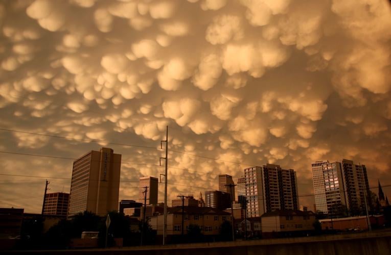
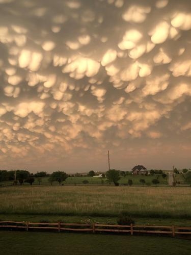
What I find most interesting about mammatus clouds is that while most clouds are formed by rising air, mammatus clouds actually form from sinking air.
These clouds are best described as cellular pouches or protrusions extending from the base of a cloud. The word, mammatus, is derived from the Latin word “mamma” which means “udder.” And that is very much what it looks like.
People are also reading…
Often the mammatus cloud is associated with severe weather, but they can occur in cirrus clouds, as well. Cirrus clouds are the highest cloud in the sky and composed entirely of ice crystals. Mammatus clouds can also occur in altostratus clouds, which are in the mid-levels of the atmosphere and blanket the sky on a cloudy day.
However, it is their association with severe weather that usually gets the most notice as people tend to have their eye to the sky on those days. So, what makes up a mammatus cloud?
Several key factors must be present for mammatus clouds to form. First is unstable air, second is wind shear, and finally a sharp temperature gradient are all needed.
When a thunderstorm is building and a cloud is rising until it can’t rise anymore and begins to spread out horizontally, this is called an “anvil cloud.” These anvil clouds usually have mammatus features that form along the base. But sometimes the saturated air inside this cloud is heavier than the air it surrounds, which will cause it to fall or descend and form the mammatus pouches.
So, back to our list. We have the instability needed for the air inside the cloud to continue to rise. There is the sharp temperature gradient that is present between the cold saturated air within the cloud and the warmer air it surrounds, and finally the wind shear, This gives it the momentum that is needed to drop and form those pouch-like protrusions.
The life span of a single lobe on a mammatus cloud is only a quick 10 minutes. However, the cloud itself can last 15 minutes to an hour or two as it continues to form lobes throughout its cycle. So if you see these beauties out there on a stormy day, grab a picture quickly!

In addition to her daily video forecasts, Tulsa World meteorologist Kirsten Lang is writing stories on weather. Each Wednesday, she'll publish…