

Earthquakes in the Ionian Sea, Greece, Documented from Little-Known Historical Sources: AD 1513–1900
1
Department of Dynamic, Tectonic & Applied Geology, Faculty of Geology and Geoenvironment, National and Kapodistrian University of Athens, 15784 Athens, Greece
2
Board of Directors, Estavromenos Campus, Hellenic Mediterranean University, 71410 Heraklion, Greece
3
International Society for the Prevention & Mitigation of Natural Hazards, 10681 Athens, Greece
*
Author to whom correspondence should be addressed.
Geosciences 2023, 13(9), 285; https://doi.org/10.3390/geosciences13090285
Submission received: 30 July 2023
/
Revised: 9 September 2023
/
Accepted: 12 September 2023
/
Published: 21 September 2023
(This article belongs to the Section Natural Hazards)
Abstract
:The seismicity in the Ionian Sea region is very high. In the historical period, many earthquakes have been reported mainly since the 16th century. In this research, we investigated the historical seismicity in the Ionian Sea, emphasizing earthquakes that have been damaging or strongly felt on Zakynthos (Zante) island. A variety of information sources, which have not been utilized so far and covering the time period from AD 1513 to 1900, were collected and examined. The sources utilized included archives, short chronicles, marginal notes, diaries and official scientific bulletins. This research reveals new information for earthquakes that have remained unknown or little-known in the seismological tradition so far. In addition, new information was found for important and already known earthquake episodes, such as the 1886 large and extensively damaging earthquake in the southwestern Peloponnese and the prolonged and destructive earthquake sequence of 1893 on Zakynthos Island, as well as for the little-known damaging earthquake of 1898. Our research adds new information about the earthquake effects in both the built and natural environments and helps also to correct earthquake dates and to identify spurious events.
1. Introduction
The region of the Ionian Sea, Greece (Figure 1), is characterized by very high seismicity. The islands of Cephalonia, Ithaki, Lefkada and Zakynthos (Zante) experience destructive earthquakes repeatedly. For example, in 1953, the islands were hit by a sequence of very strong earthquakes measuring moment magnitudes of Mw6.29, Mw6.53 and Mw6.81 [1] occurring on 9, 11 and 12 August, respectively (Figure 2). The death toll of about 480 and the extensive destructive effects caused by the 1953 seismic episode are the worst in the seismic history of Greece in about the last 140 years.
Of particular interest is the historical seismicity of Zakynthos Island. This is due to the availability of many local, Venetian and other documents, which offer plenty of information regarding earthquake occurrences and their impact on Zakynthos and on the rest of the Ionian islands. Historical and instrumental earthquakes that have occurred on Zakynthos have been listed in many earthquake catalogs, books and relevant studies, and several of them are quoted in Section 2.2. The island of Zakynthos has been affected not only by local but also by distant large-magnitude earthquakes, such as the earthquake that ruptured the southwestern Peloponnese on 27 August 1886 (Figure 2).
In this paper, we present material for the seismic history of the Ionian Sea islands, and particularly of Zakynthos, for the time interval extending from AD 1513 to 1900. Only very few earthquakes are known to have occurred in the study area before the 16th century. This is a historical rather than a geophysical paradox, in the sense that the seismicity rate in the area is high. Therefore, this lack of information very likely is due either to limited historical records or to the massive destruction of historical archives. This issue is of great importance for further examination by the historical and seismological communities.
In our investigation, we examined archives, short chronicles, memories and other local documents referring either to little-known strong earthquakes that occurred, e.g., in AD 1521, 1642, 1746 and 1821, or to already known damaging or destructive earthquakes, such as the ones of AD 1513, 1729, 1742, 1767 and 1791. Our investigation also comprised of a reexamination of a destructive earthquake, which, according to evidence, occurred in 1591. However, this earthquake is challenging enough due to the contradicting earthquake dating proposed by various authors and the resulting multiple records of more than one earthquake in the time interval from 1591 to 1593.
The last period of seismicity examined extends from 1886 to 1900. For this time interval, we draw upon information mainly from the diary of Mr. D. Kladis, a local manuscript of the 19th century that has remained little-known to the seismological community so far. The little-known unpublished “Book of Earthquakes”, as well the bulletin of the meteorological station at Zakynthos, both containing macroseismic material collected by the National Observatory of Athens (NOA) for the period from 1893 to 1915, was also utilized.
2. Materials and Methods
2.1. Seismotectonic Setting
The island of Zakynthos is situated in the northwestern tip of the Hellenic Subduction Zone, a region characterized by a complex plate boundary due to the northward subduction of the oceanic African or Nubia slab beneath Eurasia, combined with the continental collision of the Adria continental fragment of Nubia with Eurasia (see short reviews in [2,3,4]). The first process is associated with mechanisms of low-dip reverse faults, e.g., [5,6,7,8,9]. The second process, which is expressed mainly by the Cephalonia Transform Fault Zone (Figure 1), is dominated by right-lateral shear or sub-vertical faults situated within the upper crust [10,11,12,13]. The two geotectonic regimes are differentiated by the relatively high GPS velocities of ~30 mm yr−1, with respect to Europe, which is stable (Figure 2), close to the Hellenic Subduction Zone, and the lower velocities of ∼10 mm yr−1 or less in the Cephalonia Transform Fault Zone [14,15]. Both regimes, however, are characterized by high seismicity with earthquake magnitudes that reach up to about 7.0. The most recent case was a large earthquake that occurred to the south of Zakynthos on 25 October 2018 (Mw6.84) [1,3,4,16,17]. Strong earthquakes occurring near Zakynthos are usually associated with precursory foreshocks [18] or swarm-type activity [19,20]. Such seismic clusters have been observed in association with historical strong earthquakes as well, like the 1893 sequence, which is examined later.
2.2. Previous Studies
One of the very first descriptive compilations of historical earthquakes reported in Zakynthos was published in 1849 [21] and was followed up by many others [22,23,24,25,26,27], all based on local archives and/or on news reports. An effort for the systematic compilation of macroseismic observations for earthquakes occurring in Greece, including Zakynthos, was undertaken by NOA in 1893. The collected material for the period from 1893 to 1915 was organized in two unpublished manuscript volumes [28,29] deposited in the library of NOA. The macroseismic material was collected by local observers affiliated with NOA. Part of this collection was published in the “Annales de l’ Observatoire National d’ Athènes” (“Annales”), the scientific bulletin of NOA. Moreover, brief macroseismic observations were collected by the observers that serviced several local meteorological stations of NOA, including that of Zakynthos, which has operated since 1892. Therefore, several earthquakes perceptible on the island of Zakynthos have been reported in the local meteorological bulletins as well.
Little descriptive information about historical earthquakes occurring on Zakynthos has been included in the books by Sieberg [30,31]. More recently, parametric and/or descriptive catalogs containing information on historical earthquakes that have occurred on Zakynthos have been compiled by many authors, e.g., [32,33,34,35,36]. A series of parametric catalogs containing short descriptions of each earthquake event have been offered by other authors [37,38,39,40]. However, these catalogs do not provide the original texts nor their translated versions. On the contrary, a publication by Papadopoulos and Plessa [41] contains a parametric catalog along with original texts and their English translations for earthquakes occurring in the Ionian Sea. Extensive earthquake descriptions translated in English but without providing the original texts can be found elsewhere, e.g., [42,43]. Compilations of parametric and/or descriptive material and/or macroseismic observations that are useful for the study of historical seismicity in the Ionian Sea region can be also found in several local and regional studies or books, e.g., [44,45,46,47,48,49,50,51,52,53,54,55,56], with some of them being only parametric catalogs [44,45,46].
2.3. Information Sources
The information sources used in this study are classified into three main groups. The first consists of the little-known diary of D. Kladis written on Zakynthos in the late 19th century [57] (Figure 3a). The second group of information sources consists of the little-known manuscript named “Book of Earthquakes”, as well as of the Zakynthos meteorological bulletin (Figure 3b), both compiled by NOA during the late 19th century. More details about these two sources are provided in the next sub-sections.
The third group of sources utilized for the documentation of earthquakes occurring on Zakynthos in the time interval in question consists of a set of various short chronicles, marginal notes, archives, letters and personal accounts of earthquake eyewitnesses. The relevant earthquake descriptions contained in such information sources have not been utilized so far by the seismological community, although they can be found in several publications. For example, valuable information on historical earthquakes on Zakynthos was provided by an author who examined local archives [58]. Another local author [59] described the destructive seismic sequence of 1893, which he experienced himself. A series of marginal notes found in ecclesiastical books was revealed by another local author [60]. Venetian archives, like the Archivio di Stato di Venezia (A.S.V.), referring to the Ionian islands, have been examined by modern professional historians, e.g., [61]. Their examination is of value for better understanding the earthquake activity in the period from the 16th to 18th century.
2.3.1. Late 19th Century Manuscript by D. Kladis
The main source used to retrieve information for earthquakes that occurred on Zakynthos in the time interval from 1886 to 1900 is the diary by Dionysios Kladis (1850–?), a local who serviced as a schoolteacher on Zakynthos [57]. The manuscript, which covers the time interval from 4 January 1874 to 13 January 1907, was found in August 1972 and published several years later [57]. The manuscript has the form of an exercise book with a size of 23.7 cm × 37.0 cm. It contains descriptions of various political, religious, commercial, social and other events, including earthquakes, that happened on Zakynthos and on the nearby Strofades Islet (Figure 2) in the above time interval. Cross-checking with other sources indicates that D. Kladis was a reliable author [57]. This manuscript has remained unknown to the seismological community. Only an abstract of Kladis’ diary [62] was quoted [42] in relation to the earthquake of 31 January 1893 (New Style calendar, N.S.), which is analyzed later. However, the full diary of D. Kladis is utilized here for the first time.
Most of the earthquakes listed in Kladis’ manuscript have been weakly perceptible on Zakynthos, causing no damage to the island or to other places. However, a few strong and damaging earthquakes have also been reported. In addition, the manuscript contains information about distant strong earthquakes that caused destruction in other places of Greece and that affected Zakynthos as well. Dates in the diary of D. Kladis are given according to the Old Style (O.S.) calendar.
D. Kladis reported only a fraction of the small earthquakes that were perceptible on Zakynthos in the reference period. This is concluded from a comparison that we performed between the shocks reported in his manuscript and those included in the bulletins of the Zakynthos meteorological station of NOA. Hereinafter, the published manuscript by D. Kladis is referred to simply as the manuscript.
2.3.2. The Late 19th Century NOA’s “Book of Earthquakes”
The “Book of Earthquakes” is a two-volume unpublished manuscript [28,29] comprising macroseismic observations collected by local observers affiliated with NOA in several parts of Greece, including Zakynthos, in the time interval from 1893 to 1915. This manuscript has also been utilized in previous studies of Greek historical seismicity, e.g., [63,64]. Dates in the “Book of Earthquakes” are given in the N.S. style. The macroseismic collection was partly published in the “Annales of NOA” from 1893 onward. In this paper, we focus our attention only on earthquakes that caused damage or that have been strongly felt on Zakynthos. Brief macroseismic observations collected by local observers, who serviced the Zakynthos meteorological station of NOA, were also considered. Bulletins of the meteorological station are available from 1 September 1893 onward. These bulletins include meteorological observations collected daily. Moreover, they contain short notes about other phenomena, such as earthquakes felt on the island (e.g., Figure 3b). An example of the earthquakes listed in the NOA’s “Book of Earthquakes” for the year 1893 is illustrated in Figure 4.
2.4. Method
2.4.1. Introductory Remarks
The earthquakes studied in this paper are examined in chronological order. Earthquake descriptions contained in the sources used were cross-checked with other sources, if available. The earthquake descriptions are accompanied, when needed, by short explanatory notes in the form of a [note]. For example, in the statement “a strong earthquake [was felt]”, the term [was felt] was added by us. Localities that are referred to in the rest of this paper can be found in Figure 1 and Figure 2.
In the sources examined, the earthquake descriptions are in the Greek language, but here they are translated into English. The dates of the earthquake occurrences, as a rule, are given in the O.S. calendar, and in a few cases, indiction dates are provided. Such dates were converted to dates in the N.S. calendar. It is noteworthy that, in most information sources, earthquake origin times follow the Greek Orthodox religious tradition, which means that 12 h day and 12 h night cycles started at 6 a.m. and 6 p.m., respectively. For this reason, we added an explanatory note, when needed, to indicate time in terms of modern time. For example, in the first earthquake examined below, which, according to one source, occurred on 16 August 1521 “at seven o’clock at night [1.00 a.m.], dawn of Saturday”, we inserted the modern time as [1.00 a.m.].
The results of our examination are presented in Section 3.
2.4.2. Conversion of Macroseismic Intensities
NOA’s local observers, who compiled macroseismic observations for the “Book of Earthquakes” as well as for the meteorological bulletins, assigned macroseismic intensity, K, to many earthquakes. The macroseismic scale used was the 10-point Forel scale [65], which is quite similar to the so-called Rossi–Forel (RF) scale [66]. The macroseismic effects corresponding to various levels of the Forel intensity scale adopted by NOA are explained in Table 1. A scheme for the conversion of RF intensities to intensities in the EMS-98 and MCS scales is provided by experts [67] (Table 1).

Table 1.
Intensity description of the RF scale and its comparison with the EMS-98 and MCS scales [67]. An exception is intensity 10 on the RF scale, because this intensity is defined in such a way that it relates to phenomena that do not represent the strength of shaking, e.g., those due to surface faulting, or those that reach a saturation point in the scale at which the total damage refers to the total damage to buildings without antiseismic designs [67]. The RF scale is quite like the version of the 10-degree Forel scale adopted by NOA.
| Intensity in RF Scale | Intensity Description | Intensity EMS-98/MCS |
|---|---|---|
| 1 | M Microscopic vibration. | 1/1 |
| 2 | Very weak shock felt only with the help of seismographic instruments. | 2/2 |
| 3 | Extremely weak shock felt only by awake people under special circumstances favoring the shock’s observation (e.g., a person at rest). | 3/3 |
| 4 | Weak shock felt by a person in motion; it can even wake a sleeping person. Vibration of objects hanging from either the wall or the ceiling. Motion is transmitted to liquids. | 4/4 |
| 5 | Moderately strong shock. Overturning of movable objects (furniture, etc.). | 5/5 |
| 6 | Strong shock. Overturning of movable objects, cracks in the walls or in the ceilings of houses. | 5/6 |
| 7 | Fairly strong shock. Damage of buildings, chimneys overturning. | 6/7 |
| 8 | Very strong shock. Νon-solidly constructed buildings (e.g., stables, huts) are overturned. | 7 or 8/8 |
| 9 | Extremely strong shock. Solidly constructed buildings (e.g., houses) collapse. | 9/9 |
| 10 | Shock of extraordinary power. Earth layers are perturbed, ground faults break, rocks fall, etc. | -/10 |
3. Results
In this section, we present the results reached for each of the earthquakes examined, and Table 2 is a synoptic list only of the damaging earthquakes and of those that caused associated phenomena like ground failures and tsunamis.
3.1. Results for Each Earthquake Examined
- 16 April 1513 and 16 August 1521
An earthquake occurring on Zakynthos in 1521 is described by [42]: “1521 Aug. 16, Zakynthos. An earthquake occurred in Zante [Zakynthos] (Manousakis [sic], 1967)”. However, no other details are provided, although the earthquake caused damage, as it came from a relevant short chronicle published by [68]. Because the short chronicle is written in Greek and was reproduced so far only in a local Greek book [49], we considered it useful to make it available to the international community. The manuscript, which was found in the Codex Marcianus GR 99, II, Collocazione 1261, f. 112r, stored in Marciana Library, Venice, was written on Zakynthos by the local notary Mr. Th. Raftopoulos in the early 16th century [68]. The full earthquake statement reads as follows: 1521, indiction eight, day 16 of August, at seven o’clock at night [1.00 a.m.], dawn of Saturday; a large and terrible earthquake happened, like the one that occurred in 1513, indiction first, day 16 of April, but it did not last as long as that [the 1513 one] although it was stronger. [The earthquake] destroyed the interior of the castle. One soldier crushed…also his wife and one of his children. The bell and the small grommets fell, and the door of the castle destroyed. The houses in the castle as well as in the seaside were extensively annihilated.
No other document is available for the earthquake of 1521. The destructive earthquake of 16 April 1513, which occurred at the third hour of the day, i.e., 9 a.m., is known from other documents reviewed by previous authors [42,49]. The statement that the 1521 earthquake was stronger but of less duration as compared to that of 1513 implies that the 1513 earthquake likely occurred at a longer epicentral distance than that of the 1521 one.
- 1532
- (?)
A letter dating 29 April 1532 was sent by the Strofades monastery’s abbot, Daniel, to Venice, requesting building materials and defensive weapons, “since the times were turbulent”, and the monastery’s tower suffered damage from an earthquake [69] (reproduced from [70]). The exact date of the damaging earthquake is not mentioned in the letter. The earthquake of 16 August 1521 is the closest in time among the known earthquakes that took place on Zakynthos or on the Greek mainland. We may not rule out that this was a damaging earthquake. However, it is strange that the monks asked for assistance from Venice so many years after the 1521 earthquake.
A more reasonable hypothesis is that an unknown strong earthquake, occurring closer in time and space, may have caused the reported damage in the Strofades monastery. In modern times, an earthquake measuring a moment magnitude of Mw6.84 [1] took place near Strofades (Figure 2) on 25 October 2018, at 22:54:50.52 UTC, and caused serious damage to the monastery.
- September 1555
A historian [71], who examined the history of Cephalonia Island, reported on a “major earthquake” that occurred on the islands of Corfu, Cephalonia and Zakynthos (Figure 2) on 7 July 1551. Unfortunately, his information source is not provided. Other authors, writing in the late 19th century, reported on a damaging earthquake that took place on 7 July 1554 [23,58,72]. This tradition was followed by modern researchers as well [40,45]. The original source for this earthquake was an official letter from the Doge of Venice to the provvidador of Zakynthos discussing the assistance to be given to the island. This letter was found in the Libro Ordini e Terminazioni, III, p. 77, stored at the archives of Zakynthos city [23]. As no further evidence was found about the 7 July 1551 earthquake, we support that it is very likely that the historian’s account [71] refers also to the earthquake that supposedly occurred on 7 July 1554.
Ambraseys [42] expressed the opinion that the earthquake in question occurred during 1554, but the exact date is not known. Another source [73] reported on a mountain landslide that occurred on that same date near Zara (today, Zadar), about 800 km away from Zakynthos. However, there is no evidence that the landslide occurred in connection with an earthquake. Another Zakynthian historian [74] dated the earthquake on 4 September 1554 but without further explanation. It is noteworthy that the letter of the Doge of Venice is dated 24 November, 13th indiction, 1554 [23]. However, 1554 corresponds to indiction year 12 in indiction cycle 103. Additionally, indiction year 13 of indiction cycle 103 is 1555. Considering that an indiction year started on 1 September, 1 September and 24 November 1555 may represent the terminus post quem and terminus ante quem of the earthquake occurrence, respectively. Furthermore, the letter of the Doge of Venice mentions the awful misfortune that hit the island [Zakynthos] during the past months because of the earthquake. This statement favors the suggestion that the earthquake likely happened during September 1555.
- 1591–1593
Strong earthquakes supposedly occurring on Zakynthos in 1591, 1592 and 1593 have been listed in various earthquake catalogs, books, and studies but with contradictory and confusing dates. The tradition for reporting the occurrence of two earthquakes in 1592 and 1593 started around the mid-19th century and continued for several years. However, about one century later, the publication of a local marginal note [75] revealed the occurrence of a damaging earthquake on 14/24 April 1591. This note, found in the archives of Zakynthos city, was written by the notario Mr. Domenikos Romanos and reads as follows [75]: 1591. April 14, Wednesday, in about half an hour of the night [6.30 p.m.], a great earthquake happened and soon after another one but smaller, and after that a third one shook and a fourth one [occurred] as strong as the second; in the villages many stone walls without mortar fell, and the house of John Mazarakis near the castle gate [in Zakynthos city] also fell; however, within the castle many [houses] fell…and in the castle itself nothing remained standing, including the tower and the walls all around the castle and the old gate with the bell. At that time many other [earthquakes] happened, i.e., at that week, and in the next one, and later but less frequently; on Saturday 21 August [1591] at dawn another great earthquake [happened] but without damaging effects.
From the marginal note by D. Romanos, we learn that a strong and extensively damaging earthquake occurred on 14/24 April 1591. Many earthquakes, very likely aftershocks, followed for several weeks. The strong but not damaging earthquake of 21/31 August 1591 likely was a late strong aftershock, to which a maximum intensity of IV in the town of Zakynthos was assigned. Although this marginal note attracted interest among the Greek seismological community as late as 1997 and afterward, confusion about the dates of the 1591, 1592 and 1593 earthquakes increased. An author [76] referred to the occurrence of an earthquake in 1592: St. John’s church fell in ruins after the large earthquake of that year [1592]. Other authors listed not only the 1591 earthquake but also another two occurring in 1592 and 1593 [49], and another local author adopted both the 1591 and 1592 earthquakes [51]. However, only one main shock occurring in 1591 was adopted by later authors [41,61]. On the other hand, only the 1592 earthquake is listed in earthquake catalogs, which have been widely used in about the last 20 years [41,44,45]. Ambraseys (2009) [42], who was not aware of the marginal note by D. Romanos, adopted an earthquake dated 28 May 1591.
There are two questions that call for clarification: (i) How many strong earthquakes occurred on Zakynthos in the years from 1591 to 1593? (ii) What are the correct dates of these earthquakes? A thorough historiographic analysis showed convincingly that, apart from the 14/24 April 1591 earthquake, no other earthquake occurred in 1592 [61]. In the frame of the same analysis, the explanation of the wrong quotation of an earthquake occurring in 1592 was based on an examination of the Minutes (Praktika) of the Council of Zakynthos dated in the late 16th century. The Minutes, found in the archives of the Corfu State (1587–1594), refer (f.47v) to the Council’s letter requesting financial support from the Venetian administration with the aim of repairing the damage caused to the city walls by the 1591 earthquake [61]. The letter is dated 25 April 1591 (O.S.), and the Senate was informed about it on 28 May 1591. On 22 August 1591, the Senate decided to support the repair of only the officers’ houses (A.S.V., Senato, Mar, registro 52, f. 80r, [61]). Finally, a new decision to support the repair of the city walls was taken on 21 May 1592 (A.S.V., Senato, Mar, f. 113) [61]. The long delay for taking the final decision by the Senate led some authors [23,71] to conclude that the damaging earthquake occurred during May 1592. The dating error propagated through the literature for many years. Another author [42] copied an earlier historiographic analysis [23], which, however, confused the dates of the relevant letters and dated the earthquake on 28 May 1591 (N.S.) or earlier.
To conclude, based on a marginal note mentioned above [75], we adopt that the damaging main shock on Zakynthos occurred on 14/24 April 1591. The date of 28 May 1591 (N.S.) adopted by [42] is not justified as the date of that earthquake event. A thorough historiographic examination [61] showed that the earthquake supposedly occurring in May 1592 is a spurious event. An earlier author [25] reported that part of the hill, on which the Zakynthos castle is situated, collapsed because of the 1592 earthquake. Very likely, this happened with the 14/24 April 1591 earthquake.
Regarding the earthquake that supposedly took place during 1593, the only relevant publication referring to it is an original source mentioned by a local author [21]. However, later authors referring to the 1593 earthquake just copied [21] without offering further evidence. Possibly, this earthquake is an erroneous record of the 14/24 April 1591 earthquake.
- 7/17 May 1673
This is an earthquake that was reportedly felt on the islands of Crete, Cephalonia and Zakynthos (see reviews in [23,40,42,77,78]). However, the extent of the damage to each island is not clear, although one of the reports says that …many houses were overthrown, many men died, and there was damage… [40,42]. A report by the provvidador of Zakytnthos Alvise Barbaro (A.S.V., Senato Rettori, f. 86) [78], which is dated 7 October 1674, made it clear that …public buildings damaged by the terrible earthquake of the last year [1637] have been repaired…
- 27 June/8 July 1729
From several sources, we know that a destructive earthquake struck Zakynthos on that date (see reviews in [23,40,42,48]). A report by the provvidador of Zakytnthos Marc’Antonio Dolfin (A.S.V., Collegio Secreta, Relazioni di Ambasciatori, Rettori e altre cariche, b. 87) [79], which is dated 28 June 1730, says that …public buildings have been deteriorated by the time and damaged by the terrible earthquake of the 8th of July 1729…the public walls of the fortress have been heavily damaged [by the earthquake] …
- 14/25 February 1742
Another strong earthquake, which is also known from several sources, caused destruction in Zakynthos (see reviews in [23,42,48]). The church of Faneromeni was again damaged in a way like the damage caused by the 1729 earthquake. A short note found in the code of the church provides more details [60]: 7 March 1742 [O.S.], Sunday. A large earthquake happened in this island on the 14th of last February [O.S.]; afterwards many others [happened] and shook the columns of the bell tower on which the canopy and all bells are lying on; [the damage is] so extensive as to cause fear for great damage to our church and terrible danger for everything to collapse. The rest of this short note is dedicated to decisions taken by the people with the aim of repairing the damaged church.
- 24 and 25 January/4 and 5 February 1746
A short chronicle written by Mr. Alexandros Sypandros was found in the code of the Evaggelistria church in Zakynthos city [41,58,75], but it remained little known to the seismological community. It refers to a strong seismic sequence, which, however, did not cause damage. We found no further evidence for this earthquake sequence. This chronicle reads as follows: 25 January 1746 [O.S.]. At dawn of St. Gregory Theologos, Saturday, terrible earthquakes. They started at 9 o’clock of Friday during the evening liturgy [21.00]; the earthquakes terminated at the 9th hour of night [3.00 a.m., dawn Saturday] at the time of morning prayer…But after that time [the earthquakes] restarted and continued daily for more than one week. Based on this chronicle, previous authors suggested that at least two remarkable earthquakes with a maximum intensity of ΙV-V were felt. The first occurred on 24 January 1746 (O.S.) at around 15:00, and the second occurred on 25 January 1746 (O.S.) at around 03:00 [41]. The overall earthquake activity lasted for at least one week.
- 28 October/8 November 1766
From a marginal note published by the notary Mr. Efstathios Papadatos, in the late 19th century [58] and reproduced later [41,74], we learn that an earthquake was strongly perceptible on Zakynthos: 28 October 1766 [O.S.]. At Monday dawn, 5 o’clock evening [23.00], a great earthquake occurred and lasting of a quarter of an hour [certainly an exaggeration]; at the beginning [it was] slight and then became stronger. The people awake and run outdoors in the churches asking for forgiveness. The long duration of the shock, combined with that it was weak at the beginning and stronger later, implies a possibly distant source.
A detailed historiographic analysis led to the conclusion that the earthquake source was close to Ioannina city, NW Greek mainland (Figure 2), where damage was reported [80]. Very likely, the Ioannina earthquake was the one that, according to other catalogs [40,42,45], supposedly occurred near Elassona town, central Greece (Figure 2), where it caused some damage on 9 November 1766. Nevertheless, the opinion that the earthquake very likely had its source near Ioannina [79] is convincing to us.
- 11/22 July 1767
On that date, a very well-known large and destructive earthquake hit mainly Cephalonia but also Lefkada and Zakynthos islands. A lot of sources are available about this earthquake and its destructive consequences (see reviews in [40,42]). Owing to the large number of foreshocks and aftershocks, it is difficult to establish the exact origin time of the main shock [42]. Some authors [40] considered that the earthquake occurred at 4 a.m. UTC, i.e., 6 a.m. local time. The notary E. Papadatos, already mentioned before in relation to the 1766 earthquake, wrote a relevant marginal note that adds information about the earthquake’s effects on Zakynthos [74,75]: Earthquake of 11 July 1767 [O.S.]. Wednesday, around the 3rd hour of the day [around 9 a.m.], a large earthquake happened; the ground was shaken for one day and a night. People in fear run to the priests…and the people left their houses [in the city] as they were falling little by little; this happened also in the villages Katastari and Skoulikado, but in Niochori more damage was caused…
- 1767 or 1768?
Another short note dated 24 August 1768 [O.S.] was found in the code of Faneromeni church [60]. It says the following: …we would like to let you know that the οctagonal pedestal of the bell tower was so heavily damaged from the last earthquakes as to cause fear for great damage and threat to the church…Once more, the rest of the short note is dedicated to the actions needed for reparation. The document does not supply the exact dates of the causative earthquakes. As no further evidence was found for strong earthquakes occurring on Zakynthos during the year 1768, we suggest that the short note perhaps refers to the large earthquake of 11/22 July 1767 and to its aftershocks.
- 22 October/2 November 1791
This destructive earthquake is well known from several sources reviewed by previous authors [40,42]. An anonymous short chronicle says the following [74]: Earthquake of 22 October 1791 [O.S.]. At the 3rd hour and 3 min evening [21.03], dawn of St. Jacob, a terrible earthquake happened and shocked the hearts of all the Zakynthians; many houses collapsed, and I may say that all the rest ravaged and deformed. Many church buildings collapsed entirely, 16 people killed and many others injured since their arms and legs crushed. Smaller shocks were perceptible day and night for a long time.
- 1793
An earthquake occurred on Zakynthos during 1793, but dating details are missing. This earthquake was reported by a reliable local author [77], who noted that the buildings of the St. Kathrin monastery, situated near the mountain of Atheras, north Zakynthos, were ruined by the earthquake. No other source has been found for this earthquake.
- 1/13 December 1820
There is evidence that a damaging earthquake happened on Zakynthos on 1 December 1821 (O.S.) [81,82]. The relevant information comes from a letter sent by the Zakynthian priest Mr. Georgios Xenos to the abbot of the Monastery of Patmos Island, south Aegean Sea. The letter, which was found in the archive of Patmos Monastery, reads as follows [82]: 8 December 1821 [O.S.]. The church of St. John Theologos as well as the nearby church of Saints Anargyri and the vicar’s cell [all in Zakynthos city] suffered significant damage from the earthquake of 1 December 1820. The letter was sent because the two churches were shared with the Patmos Monastery. In a subsequent letter by Georgios Xenos dated 3 June 1826, addressed also to Patmos Monastery, it was reported that … the church still owes 400 talara [ducats] because of the 1820 reparation.
This earthquake is unknown to the seismological tradition. From several sources, reviewed by many authors [23,40,41,42,49], it is well known that, on 17/29 December 1820, a very strong earthquake caused extensive damage and fatalities in the island. Perhaps the 1/13 December 1820 earthquake, mentioned in the letter sent by the priest Mr. Georgios Xenos, was a strong foreshock. Alternatively, as the letter was written one year after the earthquake occurrence, we do not rule out that the priest had in mind the 17/29 December 1820 earthquake when writing his letter.
- 22 July/3 August 1837
Two short chronicles written by local people record a strong earthquake [73]. Because the relevant information has been published only in local books [41,49,51,81], although the earthquake event is not listed in widely used earthquake catalogs, e.g., [40,42,44,45], we considered it useful to include this earthquake in our discussion. The first short chronicle is contained in a manuscript written by the priest G. Xenos and reads as follows [75]: 1837, July 22 [O.S.], 9 am, great earthquake; should it had happened at night it would have caused extensive damage. The second short chronicle is contained in a manuscript written by Mr. Francesco Pilikas and reads as follows [76]: 1837, July 22, Thursday, at 9 o’clock dawn. A great earthquake happened and caused the fall of a part of the mountain above Kryo Nero [near Zakynthos city]. A landslide reportedly happened at the same place because of the 12 August 1953 large earthquake. A maximum intensity of V-VI was estimated for the 1837 earthquake [40].
- 4 February 1867 (N.S.)
This earthquake is well known for the extensive destruction that it caused on the island of Cephalonia. Authors who reviewed several sources available concluded that, on Zakynthos, the damage that was caused was insignificant [40] and was confined in the village of Skinari in the northeastern part of the island [42]. However, a press report from Zakynthos indicates that the damage to the island was more extensive. Namely, the report, which was published on 20 February, says the following [82]: Correspondence from Zakynthos, 8 February 1867…Many houses in the villages of Zakynthos fell entirely. Most of houses in the city fissured. A part of rock in the north part of the island near the sea split in two pieces and fell. The shocks did not terminate until yesterday.
- 15/27 August 1886
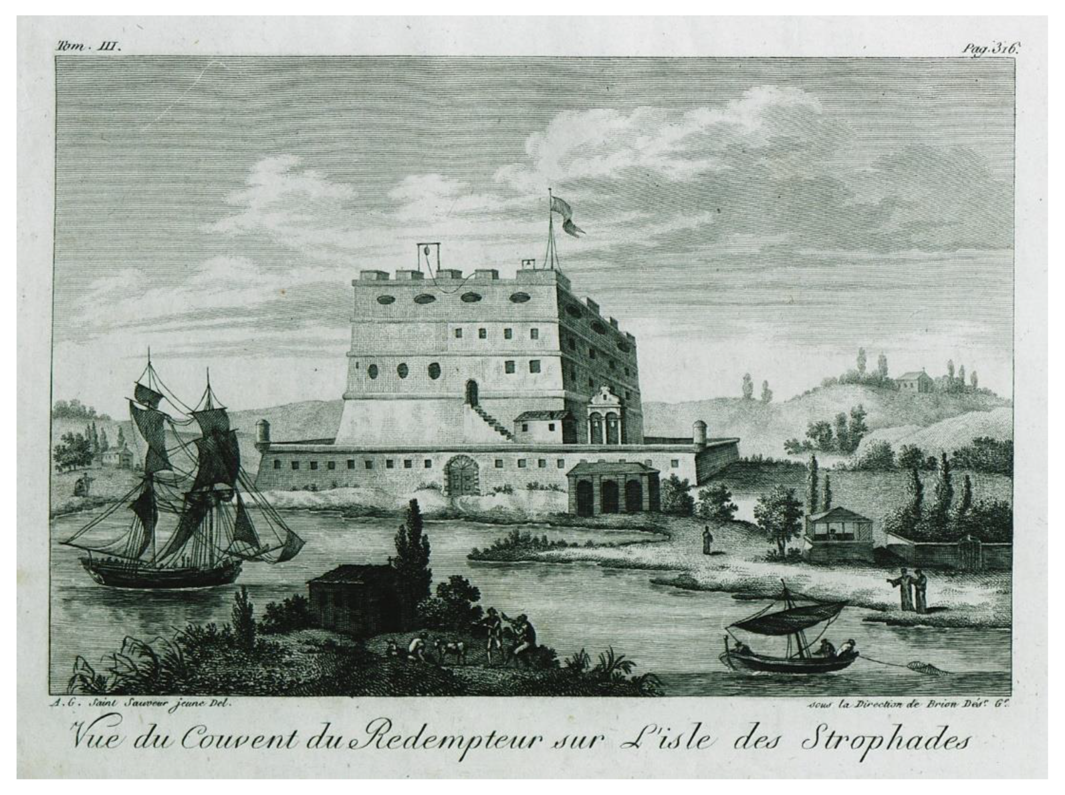
The manuscript by D. Kladis contains two notes regarding this earthquake [57]: 15 August 1886 [O.S.]. Friday, 11.20 evening. A strong earthquake [was felt], having duration of 40 s according to accurate calculations of the telegraph operators. [In Zakynthos city] all the [house] walls fissured, but no great damage noted…At the same time, this earthquake happened in Cephalonia Isl. [as well as] in Trifillia, Pyrgos, and Patras [western Peloponnese, Figure 2] and as far as Athens [Figure 1]. But the highest destruction occurred in Philiatra [western Peloponnese] ... After the earthquake, the administration of Zakynthos Monastery sent a boat to Strofades [an islet to the south of Zakynthos, Figure 2 and Figure 5 with the aim to learn what happened to the priests there.
The second note by D. Kladis reads as follows: Sunday, 18 August 1886 [O.S.]. The boat returned from Strofades and we have been informed that extensive destruction occurred there. The tower [of the Monastery] opened in many points. The chapel near the grave of Saint [Dionysios] fell. All the buildings rendered uninhabitable; the fathers sleep outdoors.
A press report, published in the aftermath of the large earthquake of 15 August 1886 in the local newspaper “Adelfotis” (n. 41, p. 1, 23 August 1886), was also reproduced [57]. The report reads as follows: No minor is the damage caused here [in Zakynthos city] because of the earthquake. All the houses damaged mainly in their roofs, many walls fell in various sites of the city, while in the country [of the island] some houses fell entirely… [In Strofades] the great Church of Panton Charas demolished, the tower and the rest buildings of the Monastery fell, while the light tower damaged. Many monks injured, all stay outdoors in tents and huts. An underground roar is still being heard, while on the small Strofades islet the ground ruptured.
Of value is also an article published by a local author [25]: 1886, August 15th [O.S.], 11.32 p.m…In Zakynthos [the earthquake] was felt…with duration of 32 s…but did not cause significant damage…In Strofades, the monastery building fissured and the cells rendered useless; no fatalities noted, because as it was said a monk shepherd observed a remote light and warned the rest monks to remove. Roar and upheaval were heard from the side of Keri and Lithakia [western Zakynthos coast] for several months before [the earthquake].
Τhe large earthquake of 27 August 1886 is well known from many sources (see reviews by [40,42,83,84,85]). The manuscript of D. Kladis, as well as a contemporary press report published by [57], provides specific information about the earthquake’s impact on the island of Zakynthos, where very likely little damage was caused. This information was completed by later local authors [25,86]. However, extensive damage was reported on the islet of Strofades, which is situated much closer to the earthquake’s source compared to the distance of Zakynthos.
Figure 5.
Copper engraving illustrating a view of the Monastery of the Savior in Strofades before the destructive earthquake of 1886 [84].
Figure 5.
Copper engraving illustrating a view of the Monastery of the Savior in Strofades before the destructive earthquake of 1886 [84].

Of particular interest are the pre-seismic and co-seismic associated phenomena. In the western part of Zakynthos, roars and upheavals were heard for several months before the earthquake. On the islet of Strofades, a remote light was observed just before the earthquake, and the ground ruptured because of the earthquake. At the same place, underground roars were heard for several days after the earthquake.
All evidence suggests that the earthquake ruptured the area of the southwestern Peloponnese (Figure 2) and was of large magnitude, which has been estimated to be as high as 8.3 [35], 7.3 [40], 7.5 [44], adopted from [39]), 7.16 ± 0.3 [45] and 6.8 ± 0.3 [84]. The earthquake left behind 326 fatalities, 796 injuries and more than 6000 houses that collapsed or were rendered beyond repair (e.g., [41]).
- 17/29 September and 1/13 December 1891
The manuscript by D. Kladis provides the following information: September 17th, 1891, Tuesday, 3 am. A strong earthquake shook our island. December 1st, 1891, Sunday, 4 am. A powerful earthquake was felt. No damage was reported from these two earthquakes.
- 9/21 August up to 6/18 November 1892
According to the manuscript by D. Kladis, a seismic sequence comprising many earthquakes shook the island of Zakynthos. However, no damage was reported. The activity initiated with small earthquakes felt on 9/21 August 1892. On 15/27 August, at 11.30 p.m., a strong earthquake happened. The shocks continued until 6/18 November 1892. From another source written by an eyewitness [59], we learn the following: The earth shaking started by mid-July [1892] with many roars…The shocks continued until 15 August 1892 [O.S.] when a first strong earthquake occurred…Apparently, this was the evening earthquake reported in the manuscript by D. Kladis.
Another remarkable earthquake occurred a few days later. August 22nd, 1892 [O.S.], Saturday, 2 am. A strong but not damaging shock was felt. The people remained outdoors until the dawn. Small earthquakes continue to happen. Everybody is in fear (manuscript by D. Kladis).
These earthquakes were perhaps early foreshocks of the strong and destructive main shock of 5/17 April 1893. Some of them were associated with underground roars.
- 23 November/5 December 1892
Very likely, this was one of the early foreshocks that preceded the destructive main shock of 5/17 April 1893: November 23rd, 1892, Monday, 1.45 am. A strong earthquake occurred. The cross at St. Mark as well as that of the Metropolis bell tower fell (manuscript by D. Kladis).
- 19/31 January 1893
Foreshock activity continued. Indeed, according to the manuscript by D. Kladis, some small earthquakes occurred until 11/23 January 1893. On that date, he wrote the following: The shocks continue as previously. Zakynthos is in motion at every moment. From another source [59], we learn the following…In the evening of 18th January [1893] a strong blatancy and pulsating ground motion downwards [occurred] and after that a rotational stir run across the island from west to east…The people run outdoors…A few houses fissured…However, this earthquake was not reported by D. Kladis.
The activity continued into the following days [59]: In the evening of 18th January a subterranean noise and a ground vibration, first downwards and then rotational from west to east, run across the island like a spasm…People run outdoors, and they saw their houses fissured…After midnight people were seized with despair because of the successive shocks. In the morning of 19th January around 6.15 am. a terrible catastrophe happened…The earthquake, with duration of 18 s or 22 s, consummated the consequences of the evening shock…One woman and a man killed…In the entire country of the island no houses remained intact, all fell. The villages of Gaitani and Keri rendered like mountains of ruins. In the city [of Zakynthos], only 200 out of 2800 houses are habitable. Large houses of good construction suffered extensive damage. Most of the churches damaged, a few ruined, like the ones of St. Trinity and of St. Stylianos…The districts of Niochori, St. Anna, Ypapantis, Ypsomatos, Ammou and St. Trinity rendered completely uninhabitable.
The last strong earthquake was also described by D. Kladis as follows: January 19th, 1893, Tuesday, 5.45 [am]. Strong earthquake, quite local. The motion was rotational and lasted 40 s; our island was shaken from its grounds. Roofs and walls of houses and churches fell like small toys. Nearly everybody, particularly the poor people, rendered homeless. The St. Trinity church destroyed. Some streets, particularly at higher ground, as well as the coastal quill suffered great fissures. All the prisons at the castle destroyed. Only 200 houses remained with small damage, all the other houses in the city demolished. The ground shaking lasted all day. The army and the staff of the public services stayed [outdoors] in tents in the George Square [today Solomos Square]. The earthquake of 19 January 1893, very likely, was a strong foreshock preceding the main shock of 5/17 April 1893. This earthquake is already known from other sources (see reviews in [40,42]).
- 20 January/1 February 1893
January 20th, 1893. The shocks continue, a strong one [happened] at 2 am. This earthquake completed the destruction caused by the earthquake one day before. The houses that survived, or suffered only small damage, now rendered useless. All the villages, except Volimes, destroyed (manuscript by D. Kladis). This was another strong foreshock preceding the main shock of 5/17 April 1893.
The manuscript also provides many details regarding the situation on the island in the days after those earthquakes. We learn that the seismic activity continued for many days, but a decrease was noted from the 2nd to the 7th of February 1893. Help was supplied to the local people from both the central government and the local authorities. Many families left the island. Two steamboats, one Greek and one Italian, as well as a British battleship, carried over several supplies for the people in need. The royal family visited the island.
In an additional note dated 9/21 February 1893, D. Kladis provided more details about the earthquake’s impact: February 9th, 1893. In Zakynthos city demolition of houses started, for those that rendered ready to collapse. According to an official report of the Chief Engineer the destruction caused by the earthquake in Zakynthos city has as follows: 300 small and ground level houses collapsed entirely. Near-to-collapse parts were demolished in 600 houses, while the remaining parts are also considered as destroyed completely. In the city, 2000 buildings as well as some churches abandoned by the scared residents. Among the near-to-collapse houses, 1300 suffered light fissures and damage to plaster. About 300 houses remained intact or suffered only minor damage. The author of the manuscript reported also that many small earthquakes, which were apparently foreshocks, were felt continuously until 1/13 April 1893.
Additional accounts for this earthquake have been offered by other authors as well, who noted that, because of the earthquake, the island was rendered a mass of ruins [84], which is perhaps an overestimation. Another author noted that those houses were still standing after the earthquake, yet they were damaged in their interior walls and roofs [87].
- 5/17 April 1893
The strong earthquake of 17 April 1893 was the main shock of persisting foreshock activity that started in December 1892, if not earlier. Several authors reviewed many sources referring to the earthquake sequence and the main shock of 1893 (e.g., see reviews in [26,40,42,51]). It is out of the scope of this paper to provide a detailed review of that important earthquake event. Therefore, we focus only on some little-known documents containing observations that complete the existing material about the effects of the intense seismic sequence of 1892–1893 on both the built and the natural environment of Zakynthos.
In his manuscript, D. Kladis presented a report that contains details about the destructive earthquake: April 5th, 1893, Monday, 7.10 am. A horrable earthquake lasting for 35 s completed the terrible work of destruction. According to documents and the testimonies of elders, this earthquake was larger and more destructive than the earthquakes of St. Loukas (1840) and of St. Jacob (1791). Fissures of one foot [in width?] opened in the jetty, while the stones displaced. The quill of the coastal road boiled [evidence of soil liquefaction]. The bell tower of St. Dionysios has been broken in the middle, only one bell survived. The church collapsed entirely; the damage exceeds the amount of 400,000 drachmas. Τhe Holy Relic [of St. Dionysios] remained intact and saved due to a miracle, then it removed to the monastery. The dome of the bell tower of Pikridiotissa Church fell. The theatre collapsed and killed Mr. Dionysios Gianniotis. The municipality building fell. The bell tower of the Metropolis Church fell from the middle upwards. The city [of Zakynthos] destroyed, everywhere one may see walls demolished or roofs overturned. All the streets are full of stones, wooden beams, and tiles, many kantounia [small streets] closed. Up to now 15 killed persons were counted in the city, while many others injured. In Gaitani village six [persons] killed. In Lithakia village one woman killed, in Roido village three [persons] killed. Gaitani suffered the heaviest destruction, more than the city [of Zakynthos] and the rest villages. An exception is the municipality of Elation [north side of the island] where it is remarkable that the earthquakes never are being felt. The kantounia [small streets] behind the Metropolis Church suffered a lot. The big wall of the Metropolis Monastery fissured and split in two. The horologes of Foro [St. Mark square] and of St. Eleftherios [church] fell. The Niochori village leveled to the ground. Nearly all churches fell. The so-called Voidi [small islet near Akrotiri at the north], in Kryo Nero, fissured and split in two. The Marathonisi [an islet at the south] collapsed and the stones fell in the sea. The cemetery destroyed, while the St. Theophilos church fell.
In the first volume of the manuscript “Book of Earthquakes” compiled by NOA [28], we found the next description for that earthquake: 17 April 1893, Zakynthos, extremely strong earthquake. A roar like that of a cannon [was heard]. The maximum strength [of the earthquake] happened at the middle of the total duration., i.e., at [around] 8 s. Hunters and workers at the S [south side] of the island lost their balance and fell; at the SE, S, SW and W coasts of the island many rocks rolled down. The city suffered great catastrophe; the same happened in most of the villages at the S and SW sides of the island, some of them destroyed nearly entirely. 23 [human] victims were counted, while the injuries are much more.
In a report of the Zakynthos prefect, reproduced in the newspaper “Kythira” (8/20 April 1893), the first assessment of the earthquake’s impact was provided. Regarding the seismic effects in the built environment, no remarkable information was found in that report. However, of interest is that, according to the press report, a small tsunami was observed: The sea withdrew for more than 20 m in the beaches of Estavromenos and Kryonerion [near Zakynthos city].
- 22 April/4 May 1893
April 22nd, the earthquakes [apparently aftershocks] continue but without damage (manuscript by D. Kladis).
- 24 October/5 November 1896
October 24th, 1896, at 2.55 a.m., a strong but not damaging earthquake was noted; and a small one at 7.40 [a.m.] (manuscript by D. Kladis).
- 21 November/3 December 1898
On 3 December 1898, a little-known strong earthquake occurred on Zakynthos. This event is listed in a previous earthquake catalog [33] (copied by [36]) with only a synoptic description and an estimated epicentral intensity of Io = 7. The documents used by us provide many details about the earthquake and its effects not only on Zakynthos but also on Amaliada, northwestern Peloponnese (Figure 2). November 21st, 1898, Saturday, 8 am. A strong earthquake [occurred] with duration of more than 5 s, but no damage was noted (manuscript by D. Kladis). The local meteorological bulletin of NOA reported this event as follows: 3 December 1898, 7.52 am, strong earthquake of 8 s in duration.
In NOA’s “Book of Earthquakes” [28], a more detailed description is provided: 3 December 1898, Zakynthos, moderately strong, 5K. [The earthquake was preceded by] a prolonged roar like that of a remote thunder. Ramshackle walls collapsed in the city and in the villages in the SW [southwest] side [of the island]. Also, many rocks rolled down in the S and NW coasts of the island as well as in a part of Voidi islet [at the north side of the city] the [so-called] Scoglio dei Trenta nove [rock of the 39’s as named after a local tradition]. The waters were very cloudy. Walking cattles stopped while trembled. According to the [observer] Mr. Minotos, [the shock came] from SE to NW; Mr. De Viazis [local historican and writer] agrees with him and reported earthquake time at 7.50 am, but the telegraph station showed 7.57 am. Books fell from the ΝW cabinet of the Foskolos Library [in the city]. In the sea inundation of 0.40 m [happened]. The sea returned to its normal place between 10 am and 15 pm. Old houses fissured, while old but repaired fissures reappeared; no fissures created in new buildings. Part of the theater fell towards east; in Cape Kryoneri [close to the city] rocks fell too. Wells dried up but in others [the water flow] increased. The water of the public fountain [became] cloudy and reddish. At the beginning [of the shock] small house bells rung; tree branches touched the ground.
The above description implies that the strong ground shaking caused limited damage in the city and in the villages of Zakynthos Island, as well as rock falls, various hydrological changes and, very likely, a small local tsunami. According to [28], the same earthquake caused fissures and the fall of mortars in houses in Amaliada city, northwestern Peloponnese (Figure 2). In that city, the shock was weak at the beginning but strong later; an estimated intensity as high as 6K, i.e., V in the EMS-98 scale, was assigned [28].
- 10/22 January 1899
January 10th, 1899, Sunday, 10.35 [a.m.]. An earthquake felt but not damaging [on Zakynthos]. It destroyed the towns of Kyparissia and Philiatra [SW Peloponnese] (manuscript by D. Kladis). The meteorological bulletin reported this event as follows: 22 January 1899, 10.50 am, earthquake [felt]. In the “Book of Earthquakes” [28], the following is reported: 22 January 1899, Zakynthos, 4K [IV in the EMS-98 scale], maximum strength noted by the middle [of the shaking]. According to [NOA’s local observer] Mr. De Viazis [the earthquake occurred at] 10.30 [am]; after the earthquake the sea became cloudy, and the water level rose about 0.2 to 0.4 m. On 11 am it [the sea water] was still cloudy. Very likely, a small local tsunami was triggered. A local tsunami of 1 m in height was also reported in Marathoupoli in the epicentral area. This earthquake is known from other sources as well (see reviews in [40,42,83]).
- 15 April 1899
On 15 April 1899 (N.S.), another strong earthquake was reported on Zakynthos [28]. The relevant account reads as follows: 15 April 1899, Zakynthos, 4K, maximum strength noted by the middle and the end [of the shaking]. A ramshackle wall collapsed. According to [NOA’s observer] Mr. De Viazis [the earthquake occurred on] 6.31 am, house bells rung and the sea became cloudy. Very likely, this was the same earthquake that, according to [28], was strongly felt in the city of Amaliada, NW Peloponnese, with an intensity of 6K. The meteorological bulletin also reported this event on Zakynthos: 15 April 1899, 6.32 am, 4K, duration 23 s. The long duration indicates a large epicentral distance. This earthquake is mentioned also by another author [42].
- 17/30 September 1900
September 17th, 1900 [O.S.], Sunday, 7.45 pm. During a music festival taking place at the Poet’s Square, five crackers stroke at the St. Pantes church. The people, who did not know what was going on, run away. At that moment a strong earthquake happened and doubled the panic but without further troubles (manuscript by D. Kladis). In the local meteorological bulletin, the earthquake was recorded at 7.30 p.m., and an intensity of 5K [V in the EMS-98 scale] was assigned (Figure 3b). In [28], the following is reported: 30 September 1900, Zakynthos, 5K. A roar like that of a cannon preceded and followed [the earthquake]. Two sequential vibrations [were felt]. The house bells rung alone. Books fell and small fissures [opened] in a few houses.
3.2. Remarks on the Results
Our investigation revealed several earthquakes, which remained either unknown or little-known in the seismological tradition so far, such as the earthquakes that occurred in 1746, 1793, 1837, 1891 and 1898. For earthquakes that were already known, we completed the existing information regarding the perceptibility of the respective earthquakes and their impact on the built and natural environments, including those of 1673, 1729, 1742, 1767 and 1791. A list of the damaging earthquakes examined can be found in Table 2.
Our research helped also to correct earthquake dates, e.g., for those that occurred in 1555 and 1591, and to identify spurious events with a characteristic example referring to earthquakes that supposedly occurred in the time interval of 1591–1593. We concluded that, very likely, the only earthquake that occurred in that time interval was the one of 14/24 April 1591, which caused significant damage on Zakynthos.
Of particular interest is the new material found for a series of important seismic episodes. From many sources, it is well known that, on 27 August 1886, a large and extensively destructive earthquake ruptured the area of the southwestern Peloponnese, Greek mainland. However, very little is known about the earthquake’s impact on Zakynthos. The new sources we examined revealed many details concerning the damage caused in the city and the villages of Zakynthos Island as well as the serious damage and ground rupture observed on the islet of Strofades situated to the south of Zakynthos.
A more detailed view was also obtained regarding the seismic sequence that started in December of 1892, if not earlier, and culminated in the very strong, well-known main shock of 5/17 April 1893. In the meantime, at least two strong foreshocks occurred. Our research revealed plenty of new information about the destructive effects caused, not only in Zakynthos city but also in many villages of the island, by the foreshocks and by the main shock. The main shock also caused ground failures, such as rock falls and soil liquefaction.
A little-known event is the earthquake that shook both Zakynthos and the northwestern part of the Peloponnese, Greek mainland, on 3 December 1898 (N.S.). The documents examined provided many details about the earthquake and its consequences not only on Zakynthos but also on Amaliada city, the Peloponnese. On Zakynthos, remarkable damage as well as hydrological changes and rock falls were caused. Damage was also caused in Amaliada.
The examination of many information sources, which have not been utilized so far, helped to substantially improve the record of the historical seismicity in the Ionian Sea and particularly on Zakynthos Island.
Table 2.
List of earthquakes that caused damage and/or environmental effects, such as ground failures and tsunamis. Dates are according to the New Style calendar; time is UTC. Maximum intensity Io is in the EMS-98/MCS scales. Earthquake parameters were taken from the sources shown in the reference column. The estimated intensity in the Environmental Seismic Intensity Scale (ESI [88]) is shown in the column of Remarks. TP stands for the present paper. Symbol * indicates the references from which respective parameters have been taken.
| Date DD.MM.YYYY | Time HH:MM:SS | Mw | Lat/Long | Io (Place) | Remarks | Reference |
|---|---|---|---|---|---|---|
| 16.04.1513 | 23: | 6.5 | 37.6/20.8 | 8/8 (Zakynthos) * | [45], TP * | |
| 16.08.1521 | 02:07:37 | 6.3 | 37.7/20.8 | 8/8 (Zakynthos) * | [45], TP * TP | |
| 1532 (?) | Damage in Strofades | |||||
| 09.1555 | Damage (Zakynthos) | TP | ||||
| 24.04.1591 * | 16:30 | 6.6 | 37.7/20.8 | 9/9 (Zakynthos) | [45], TP * | |
| 07.05.1673 | 6.0 | 36.0/22.0 | 6/7 (Heraklio, Crete), many fatalities 6/7 (Zakynthos) | [78] | ||
| 08.07.1729 * | 02: | 6.28 | 37.851/20.808 | 8/8 (Zakynthos) | [45], TP * | |
| 25.02.1742 | night | 6.61 * | 37.710/21.022 * | 9/9 (Zakynthos) | TP, [45] * | |
| 22.07.1767 | 04: | 6.65 | 38.268/20.464 | 10/10 (Lixouri, Cephalonia) 6–7/7–8 (Zakynthos) * | [45], TP * | |
| 02.11.1791 | 21:03 * | 6.8 | 37.9/21.0 | 10/10 (Zakynthos) 16 fatalities | [40], TP * | |
| 1793 | 7–8/8 (Zakynthos) | TP | ||||
| 13.12.1820 | 7–8/8 (Zakynthos) | Foreshock? | ||||
| 03.08.1837 | 07:00 | 5–6/6–7 (Zakynthos) | Landslide VI-VII (ESI-07) | [41] | ||
| 04.02.1867 | 04:19 | 7.15 | 38.233/20.424 | 10/10 (Lixouri, Cephalonia) | [45] | |
| 27.08.1886 | 21:32 | 6.8 * | 37.1/21.7 * | 9–10/9–10 (Philiatra, Gargaliani, SW Peloponnese) | Ground fissures, soil liquefaction, local tsunami (all in epicentral area; VII-VIII ESI-07); local tsunami (Zakynthos) | TP, [78] * |
| 04.12.1892 | 23:45 | 5–6/6–7 (Zakynthos) | Foreshock (?) | |||
| 31.01.1893 | 03.45 | 6.3 * | 8–9/8–9 (Zakynthos) 2 fatalities | Foreshock | TP, [40] * | |
| 01.02.1893 | 00: 00 | 8–9/8–9 (Zakynthos) | Foreshock | TP, [40] * | ||
| 17.04.1893 | 05:10 | 6.5 * | 37.68/20.81 * | 9–10/9–10 (Zakynthos), 25 fatalities, soil liquefaction, landslides, rock falls, small tsunami | Main shock VII-VIII (ESI-07) | TP, [40] * |
| 03.12.1898 | 05:57 | 6–7/7–8 (Zakynthos), rock falls, hydrological changes, small tsunami or seiche | VI-VII ESI-07 | TP | ||
| 22.01.1899 | 08:30 | 6.5 * | 9/9 (Kyparissia, SW Peloponnese), 5/5 (Amalias, NW Peloponnese), 4 (Zakynthos), local tsunami | TP, [45] * | ||
| 15.04.1899 | 04:31 | 5/5 (Amalias, NW Peloponnese), 4/4 (Zakynthos) | TP | |||
| 30.09.1900 | 17:30 | 4–5/4–5 (Zakynthos) | TP |
4. Discussion
In the present paper, we intended to present and evaluate the observational material from the various information sources collected. The information found for most of the earthquakes examined came from more than one independent source. No major contradiction was noted between the information that came from different sources for a single earthquake event. Therefore, we consider that our results, in general, are reliable.
Although there are cases in which date correction is possible, e.g., the earthquakes of 1555 and 1591, the dates of a few other events remain questionable, such as for the earthquakes of 1532, 1768 and 1/13 December 1820.
5. Conclusions
A total of 27 earthquake episodes were examined for Zakynthos Island, Ionian Sea, based on new information sources collected for the time interval from AD 1513 to 1900. Our investigation included unknown, little-known and well-known earthquakes. The material collected substantially enriched the historical record of the historical seismicity in the area and time interval considered because it provided new information about earthquakes’ impact on Zakynthos Island, on the islet of Strofades, as well as on the western Peloponnese. The earthquake impact refers not only to earthquake perceptibility and to destructive effects, if any, but also to ground failures caused, such as landslides, ground ruptures, rock falls and soil liquefaction, as well as to other associated phenomena, including local tsunamis, hydrological changes and supposed precursory phenomena.
The new material found is helpful for better understanding seismicity and for improving seismic hazard assessments in the Ionian Sea.
Author Contributions
Conceptualization, I.T.; methodology and investigation, I.T. and G.A.P.; writing—original draft preparation, I.T.; writing—review and editing, I.T. and G.A.P.; visualization, I.T. All authors have read and agreed to the published version of the manuscript.
Funding
This research received no external funding.
Data Availability Statement
Details on the data sources used are provided in the main text.
Acknowledgments
Conflicts of Interest
The authors declare no conflict of interest.
References
- International Seismological Centre. The ISC-GEM Global Instrumental Earthquake Catalogue, #Version 10.0-Released on 21 March 2023. Available online: https://doi.org/10.31905/D808B825 (accessed on 27 July 2023).
- Bocchini, G.M.; Brüstle, A.; Becker, D.; Meier, T.; van Keken, P.E.; Ruscic, M.; Papadopoulos, G.A.; Rische, M.; Friederich, W. Tearing, segmentation, and backstepping subduction in the Aegean: New insights from seismicity. Tectonophysics 2018, 734–735, 96–118. [Google Scholar] [CrossRef]
- Cirella, A.; Romano, F.; Avallone, A.; Piatanesi, A.; Briole, P.; Ganas, A.; Theodoulidis, N.; Chousianitis, K.; Volpe, M.; Bozionellos, G. The 2018 Mw6.8 Zakynthos (Ionian Sea, Greece) earthquake: Seismic source and local tsunami characterization. Geophys. J. Int. 2020, 221, 1043–1054. [Google Scholar] [CrossRef]
- Ganas, A.; Briole, P.; Bozionelos, G.; Barberopoulou, A.; Elias, P.; Tsironi, V.; Valkaniotis, S.; Moshou, A.; Mintourakis, I. The 25 October 2018 Mw = 6.7 Zakynthos earthquake (Ionian Sea, Greece): A low-angle fault model based on GNSS data, relocated seismicity, small tsunami and implications for the seismic hazard in the west Hellenic Arc. J. Geodyn. 2020, 137, 101731. [Google Scholar] [CrossRef]
- Le Pichon, X.; Angelier, J. The Hellenic Arc and Trench system: A key to the neotectonic evolution of the Eastern Mediterranean area. Tectonophysics 1979, 60, 1–42. [Google Scholar] [CrossRef]
- Papadopoulos, G.A.; Kondopoulou, D.; Leventakis, G.A.; Pavlides, S. Seismotectonics of the Aegean region. Tectonophysics 1986, 124, 67–84. [Google Scholar] [CrossRef]
- Anderson, H.; Jackson, J.A. Active tectonics of the Adriatic region. Geophys. J. Int. 1987, 91, 937–983. [Google Scholar] [CrossRef]
- Papazachos, B.C. Large seismic faults in the Hellenic arc. Ann. Geophys. 1996, 39, 891–903. [Google Scholar] [CrossRef]
- Shaw, B.; Jackson, J. Earthquake mechanisms and active tectonics of the Hellenic subduction zone. Geophys. J. Int. 2010, 181, 966–984. [Google Scholar] [CrossRef]
- Scordilis, E.M.; Karakaisis, G.F.; Karakostas, B.G.; Panagiotopoulos, D.G.; Comninakis, P.E.; Papazachos, B.C. Evidence for transform faulting in the Ionian Sea: The Cephalonia Island earthquake sequence of 1983. Pure Appl. Geophys. 1985, 123, 388–397. [Google Scholar] [CrossRef]
- Kiratzi, A.; Louvari, E. Focal mechanisms of shallow earthquakes in the Aegean Sea and the surrounding lands determined by waveform modelling: A new database. J. Geodyn. 2003, 36, 251–274. [Google Scholar] [CrossRef]
- Sachpazi, M.; Hirn, A.; Clément, C.; Haslinger, F.; Laigle, M.; Kissling, E.; Charvis, P.; Hello, Y.; Lépine, J.C.; Sapin, M.; et al. Western Hellenic subduction and Cephalonia Transform: Local earthquakes and plate transport and strain. Tectonophysics 2000, 319, 301–319. [Google Scholar] [CrossRef]
- Kokinou, E.; Papadimitriou, E.; Karakostas, V.; Kamberis, E.; Vallianatos, F. The Kefalonia transform zone (offshore western Greece) with special emphasis to its prolongation towards the Ionian abyssal plain. Mar. Geophys. Res. 2006, 27, 241–252. [Google Scholar] [CrossRef]
- Billiris, H.; Paradissis, D.; Veis, G.; Avallone, A.; Briole, P.; McClusky, S.; Nocquet, J.-M.; Palamartchouk, K.; Parsons, B. A new velocity field for Greece: Implications for the kinematics and dynamics of the Aegean. J. Geophys. Res. 2010, 115, B10403. [Google Scholar] [CrossRef]
- Pérouse, E.; Chamot-Rooke, N.; Rabaute, A.; Briole, P.; Jouanne, F.; Georgiev, I.; Dimitrov, D. Bridging onshore and offshore present-day kinematics of central and eastern Mediterranean: Implications for crustal dynamics and mantle flow. Geochem. Geophys. Geosyst. 2012, 13, Q09013. [Google Scholar] [CrossRef]
- Sokos, E.; Gallovič, F.; Evangelidis, C.P.; Serpetsidaki, A.; Plicka, V.; Kostelecký, J.; Zahradník, J. The 2018 Mw6.8 Zakynthos, Greece, Earthquake: Dominant Strike-Slip Faulting near Subducting Slab. Seismol. Res. Lett. 2020, 91, 721–732. [Google Scholar] [CrossRef]
- Papazachos, B.; Kiratzi, A.; Papadimitriou, E. Regional focal mechanisms for earthquakes in the Aegean area. Pure Appl. Geophys. 1991, 136, 405–420. [Google Scholar] [CrossRef]
- Papadopoulos, G.A.; Agalos, A.; Minadakis, G.; Triantafyllou, I.; Krassakis, P. Short-Term Foreshocks as Key Information for Main shock Timing and Rupture: The Mw6.8 25 October 2018 Zakynthos Earthquake, Hellenic Subduction Zone. Sensors 2020, 20, 5681. [Google Scholar] [CrossRef]
- Papadimitriou, E.; Gospodinov, D.; Karakostas, V.; Astiopoulos, A. Evolution of the vigorous 2006 swarm in Zakynthos (Greece) and probabilities for strong aftershocks occurrence. J. Seismol. 2013, 17, 735–752. [Google Scholar] [CrossRef]
- Mouslopoulou, V.; Bocchini, G.M.; Cesca, S.; Saltogianni, V.; Bedford, J.; Petersen, G.; Gianniou, M.; Oncken, O. Earthquake swarms, slow slip and fault interactions at the western-end of the Hellenic subduction system precede the moment Mw 6.9 Zakynthos earthquake, Greece. Geochem. Geophys. Geosyst. 2020, 21, e2020GC009243. [Google Scholar] [CrossRef]
- Chiotis, P. Istorika Apomnimonevmata tis Νisou Zakynthou (Historical Memoirs of Zakynthos Island). Kerkyra Anastatic Ed. N. Karavias Public Athens 1849, 1, 223. (In Greek) [Google Scholar]
- Chiotis, P. Istorika Apomnimonevmata tis Νisou Zakynthou (Historical Memoirs of Zakynthos Island). Kerkyra Anastatic Ed. N. Karavias Public Athens 1858, 2, 633. (In Greek) [Google Scholar]
- Barbiani, D.G.; Barbiani, B.A. Mémoire sur les tremblements de terre dans l île de Zante. Mém. Acad. Sci. Dijon 1864, 112. [Google Scholar]
- Schmidt, J.F. Studien über Erdbeben. A Georg. Leipz. 1879, 360. [Google Scholar]
- Chiotis, P. Istoriki apopsis peri seismon en Elladi kai idios en Zakyntho (A historical view of earthquakes in Greece and particularly in Zakynthos). Kipseli 1886, 13, 46. (In Greek) [Google Scholar]
- Mitzopoulos, C. Das grosse Erdbeben auf der insel Zante im Jahren 1892. Gotha 1893, 39, 166–174. [Google Scholar]
- Issel, A.; Agamennone, G. Cronistoria sismica di Zante. Ann. Dell’ Uff. Cent. Di Meteorol. E Geodin. 1894; XV(I). [Google Scholar]
- Book of Earthquakes:1893–1899; National Observatory of Athens: Athens, Greece. (In Greek)
- Book of Earthquakes:1902–1915; National Observatory of Athens: Athens, Greece. (In Greek)
- Sieberg, A. Untersuchungen über Erdbeben und Bruchschollenbau im östlichen Mittelmeergebiet: Ergebnisse einer Erdbebenkundlichen Orientreise. Denksschr. Mediz. Naturwiss. Gesellsch. Z. Jena 1932, 8, 113. [Google Scholar]
- Sieberg, A. Erdbebengeographie-Handbuch der Geophysic. Verag Berl. 1932, 4, 1005. [Google Scholar]
- Galanopoulos, A.G. A Seismic Geography of Greece (Sismiki Geografia tis Ellados). Ann. Geogol. Pays Hellen. 1955, 6, 83–121, (In Greek with English Abstract). [Google Scholar]
- Galanopoulos, A.G. Greece—A Catalog of Shocks with I ≥ VI or M ≥ 5 for the Years 1801–1958; University of Athens Greece: Athens, Greece, 1960; p. 119. [Google Scholar]
- Galanopoulos, A.G. Greece—A Catalog of Shocks with Io ≥ VII for the Years Prior to 1800; University of Athens Greece: Athens, Greece, 1961; p. 19. [Google Scholar]
- Galanopoulos, A.G. The Damaging shocks and the Earthquake Potential of Greece. Ann. Geol. Pays Hellen. 1981, 30, 648–724. [Google Scholar]
- Shebalin, N.V.; Kárník, V.; Hadzievski, D. (Eds.) UNDP/UNESCO Survey of the Seismicity of the Balkan Region-Catalogue of Earthquakes, Part II, Prior to 1901; UNESCO: Skopje, Republic of Macedonia, 1974; p. 69. [Google Scholar]
- Papazachos, B.C.; Comninakis, P.E. A catalogue of earthquakes in Greece and the surrounding area for the period 1901–1980. Publ. Univ. Thessalon. Geophys. Lab. 1982, 5, 1–146. [Google Scholar]
- Papazachos, B.C.; Papazachou, C. The Earthquakes of Greece; Ziti Publication: Thessaloniki, Greece, 1989; p. 347. (In Greek) [Google Scholar]
- Papazachos, B.C.; Papazachou, C. The earthquakes of Greece; Ziti Publication: Thessaloniki, Greece, 1997; p. 304. [Google Scholar]
- Papazachos, B.C.; Papazachou, C. The Earthquakes of Greece; Ziti Publication: Thessaloniki, Greece, 2003; p. 286. (In Greek) [Google Scholar]
- Papadopoulos, G.A.; Plessa, A. Historical earthquakes and tsunamis of the south Ionian Sea occurring from 1591 to 1837. Bull. Geol. Soc. Greece 2001, 34, 1547–1554. [Google Scholar] [CrossRef]
- Ambraseys, N.N. Earthquakes in the Mediterranean and Middle East, A Multidisciplinary Study of Seismicity up to 1900; Cambridge University Press: Cambridge, UK, 2009; p. 947. [Google Scholar]
- Papadopoulos, G.A.; Daskalaki, E.; Fokaefs, A.; Giraleas, N. Τsunami hazard in the Εastern Μediterranean sea: Strong earthquakes and tsunamis in the west Hellenic arc and trench system. J. Earthq. Tsunamis 2010, 4, 145–179. [Google Scholar] [CrossRef]
- Grünthal, G.; Wahlström, R. The European-Mediterranean Earthquake Catalogue (EMEC) for the last millennium. J. Seismol. 2012, 16, 535–570. [Google Scholar] [CrossRef]
- Stucchi, M.; Rovida, A.; Capera, A.A.G.; Alexandre, P.; Camelbeeck, T.; Demircioglu, M.B.; Gasperini, P.; Kouskouna, V.; Musson, R.M.W.; Radulian, M.; et al. The SHARE European Earthquake Catalogue (SHEEC) 1000–1899. J. Seismol. 2013, 17, 523–544. [Google Scholar] [CrossRef]
- Guidoboni, E.; Ferrari, G.; Tarabusi, G.; Sgattoni, G.; Comastri, A.; Mariotti, D.; Ciuccarelli, C.; Bianchi, M.G.; Valensise, G. CFTI5Med, the new release of the catalogue of strong earthquakes in Italy and in the Mediterranean area. Sci. Data 2019, 6, 1–15. [Google Scholar] [CrossRef] [PubMed]
- Kouskouna, V.; Makropoulos, K.C.; Tsiknakis, K. Contribution of historical information to a realistic seismicity and hazard assessment of an area. In Materials for the CEC Project Review of Historical Seismicity in Europe; Albini, P., Moroni, A., Eds.; CNR-Consiglio Nazionale delle Ricerche: Milano, Italy, 1993; Volume 1, pp. 195–206. [Google Scholar]
- Albini, P.; Ambraseys, N.N.; Monachesi, G. Material for the investigation of the seismicity of the Ionian Islands between 1704 and 1766. In Materials for the CEC Project Review of Historical Seismicity in Europe; Albini, P., Moroni, A., Eds.; CNR-Consiglio Nazionale delle Ricerche: Milano, Italy, 1994; Volume 2, pp. 11–26. [Google Scholar]
- Lekkas, E.; Kolyva, M.; Antonopoulos, G.; Kopanas, I. Oi Sismoi tis Zakynthou (The Earthquakes of Zakynthos). Zakynthos 1997, 3, 78. (In Greek) [Google Scholar]
- Spyropoulos, P.J. Chroniko ton Seismon tis Ellados apo tin Arcxaiotita Mexri Simera (A Chronicle of Greek Earthquakes from the Antiquity up Today); Dodoni Publication: Athens, Greece, 1997; p. 453. (In Greek) [Google Scholar]
- Lymouris, A. Oi Seismoi sti Zakynthos (Earthquakes in Zakynthos); Periplous Publication: Athens, Greece, 2001; p. 156. (In Greek) [Google Scholar]
- Albini, P.; Vogt, A. Glimpse into the Seismicity of the Ionian Islands Between 1658 and 1664. In Historical Seismology; Fréchet, J., Meghraoui, M., Stucchi, M., Eds.; Springer: Berlin/Heidelberg, Germany, 2008; pp. 43–91. [Google Scholar]
- Albini, P. Venetian documents on earthquakes within and at the western borders of the Ottoman empire (17th–18th centuries). In Proceedings of the Natural Disasters in the Ottoman Empire, Rethymnon, Greece, 10–12 January 1997; Zachariadou, E., Ed.; Crete University Press: Rethymnon, Greece, 1999; pp. 67–88. [Google Scholar]
- Kouskouna, V.; Sakkas, G. The University of Athens Hellenic Macroseismic Database (HMDB.UoA): Historical earthquakes. J. Seismol. 2013, 17, 1253–1280. [Google Scholar] [CrossRef]
- Mavroulis, S.; Lekkas, E. Revisiting the Most Destructive Earthquake Sequence in the Recent History of Greece: Environmental Effects Induced by the 9, 11 and 12 August 1953 Ionian Sea Earthquakes. Appl. Sci. 2021, 11, 8429. [Google Scholar] [CrossRef]
- Albini, P. Documenting earthquakes in the United States of the Ionian Islands, 1815–1864. Seismol. Res. Lett. 2020, 91, 2554–2562. [Google Scholar] [CrossRef]
- Demetis, I.M. Kyriotera Symvanta tis Nisou Zakynthou 1874–1907, ypo D. Kladis (Main Events in Zakynthos Island 1874–1907; Kladis, D., Ed.; Trimorpho Publication: Zakynthos, Greece, 2004; p. 385. (In Greek) [Google Scholar]
- Zois, L.X. Oi en Zakyntho seismoi (The earthquakes of Zakynthos). Ai Mousai. 1893, 1, 167. (In Greek) [Google Scholar]
- Spandonis, N.I. I katastrofi tis Zakynthou (The catastrophe of Zakynthos). Estia 1893, B, 94–96. (In Greek) [Google Scholar]
- Marinos, P.I. To kampanario tis Faneromenis (The bell-tower of Faneromeni church). Eptanisiaka Fylla 1955, 2, 8–9. (In Greek) [Google Scholar]
- Tzivara, P. Venetokratoumeni Zakynthos 1588–1594 (Zakynthos under Venetian Occupation 1588–1594); Enalios Publication: Athens, Greece, 2009; p. 710. (In Greek) [Google Scholar]
- Demetis, I. Zakynthos through the diary of D. Kladis. Proc. Confer. Union Heptanisa Greece Acad. Athens 2005, 106–108. [Google Scholar]
- Papadopoulos, G.A. (Ed.) Historical Earthquakes and Tsunamis in the Corinth Rift, Central Greece; Institute of Geodynamics, National Observatory of Athens, Publication No 12: Athens, Greece, 2000; p. 120. [Google Scholar]
- Triantafyllou, I.; Koukouvelas, I.; Papadopoulos, G.A.; Lekkas, E. A Reappraisal of the Destructive Earthquake (Mw5.9) of 15 July 1909 in Western Greece. Geosciences 2022, 12, 374. [Google Scholar] [CrossRef]
- Forel, F.A. Intensity scale. Arch. Sci. Phys. Nat. 1881, 6, 465–466. [Google Scholar]
- de Rossi, M.S. Programma dell’osservatorio ed archivio centrale geodinamico presso il R. Comitato Geologico d’Italia. Bull. Vulcan. Italy 1883, 10, 3–128. [Google Scholar]
- Musson, R.M.W.; Grünthal, G.; Stucchi, M. The comparison of macroseismic intensity scales. J. Seismol. 2010, 14, 413–428. [Google Scholar] [CrossRef]
- Manousakas, M.I. Anekdota chronica simeiomata kai eggrafa (1506–1521) tou notariou Zakynthou Theodorou Raftopoulou (Unpublished chronicles and documents (1506–1521) of the notary of Zakynthos Theodore Raftopoulos). In Proceedings of the Praktika 3rd Panioniou Conference, Athens, Greece, 23–29 September 1965; Volume 1, pp. 211–227. (In Greek). [Google Scholar]
- Kolyvà, M. Miracolo di San Marco. La translatio Sancti Marci, il monastero della Beata Vergine delle isole Strofadi (Zante) ed il mosaico della Cappella di San Clemente nella Basilica di San Marco di Venezia. Thesaurismata 2015, 45, 181–197. [Google Scholar]
- Marin, S.; Diarii, I. Edizione a cura di F. Stefani—G. Berchet—N. Barozzi. Venetia 1886, 56, 265–266. [Google Scholar]
- Tsitselis, E.A. Kefalliniaka Symmikta (Cefalinian Composites). Athens 1960, 2, 687. (In Greek) [Google Scholar]
- Katramis, N. Filologika Analekta Zakynthou (Philological Miscellaneous of Zakynthos). Zakynthos 1880, 488. [Google Scholar]
- Bonito, M. Terra Tremante. Ristampa (Anastatic Edition) 1980, Arnaldo Forni Editore: Napoli, Greece, 1693; 822.
- Zois, L.X. Istoria tis Zakynthou (A history of Zakynthos). Athens, 1955; 440. (In Greek) [Google Scholar]
- Konomos, N. Zakynthina Chronika 1485–1953 (Zakynthian Chronicles 1485–1953). Athens, 1970; 191. (In Greek) [Google Scholar]
- Konomos, N. Zakynthos 1478–1978. Athens, 1979; 253. (In Greek) [Google Scholar]
- De Viazis, S. Istorika analekta Zakynthou (Historical miscellaneous of Zakynthos). Neos Aion 1891, 11, 7. (In Greek) [Google Scholar]
- Papadopoulos, G.A. Earthquakes and Tsunamis in Crete: The Hellenic Arc, 2000 BC–AD 2010; Ocelotos Publication: Athens, Greece, 2011; p. 415. [Google Scholar]
- Arvanitakis, D. (Ed.) Oi Anafores ton Veneton Provlepton of Zakynthos 16th–18th Aiones (Reports of the Venetian Provvidador of Zakynthos 16th–18th Centuries); Hellenic Institute of Byzantine and Post-Byzantine Studies of Venice: Venetia, Italy, 2000; p. 546. (In Greek) [Google Scholar]
- Papaioannou, I. I seismiki drasi sti Thessalia kata tous 16–18 aiones (The seismic activity in Thessalia during the 16th–18th centuries). Thessal. Imerologio 2017, 72, 1–44. (In Greek) [Google Scholar]
- Vranousi, E. Ena metochi tis Monis Patmou sti Zakyntho (A share church of Patmos Monastery in Zakynthos). In Proceedings of the Praktika 3rd Panioniou Conference, Athens, Greece, 23–29 September 1965; Volume 1, pp. 35–46. (In Greek). [Google Scholar]
- Anonymous. O seismos tis 4 Fevrouariou 1867 (The earthquake of 4 February 1867). Newsp. Aion. Athens, 1867; 2216. (In Greek) [Google Scholar]
- Galanopoulos, A.G. Das Erdbeben von Messenien vom 22 Januar 1899. Prakt. Athens Acad. 1941, 16, 127–134. [Google Scholar]
- Enepekides, P.K. O foveros seismos tou 1886 stin Peloponniso (The terrible earthquake of 1886 in Peloponnese). Papyros Press Hist. Illus. 1997, 351, 28–33. (In Greek) [Google Scholar]
- Grasset de Saint-Sauveur, A. Voyage Historique, Littéraire et Pittoresque dans les îles et Possessions Ci-Devant Vénitiennes du Levant; Chez Tavernier: Paris, France, 1800; Part III; pp. 306–326. [Google Scholar]
- Xenopoulos, G. Oi seismoi tou 1893 (The 1893 earthquakes). Estia, 1893; 82–83. (In Greek) [Google Scholar]
- Vellianitis, T. Meta ton seismon (After the earthquake). Estia, 1893; 91–93. (In Greek) [Google Scholar]
- Michetti, A.M.; Esposito, E.; Guerrieri, L.; Porfido, S.; Serva, L.; Tatevossian, R.; Vittori, E.; Audemard, F.; Azuma, T.; Clague, J.; et al. Intensity Scale ESI 2007. Mem. Descr. Carta Geol. D’Italia 2007, 74, 11–20. [Google Scholar]
Figure 1.
Elements of the Hellenic Subduction Zone and the study area (inset, see Figure 2). Arrows show lithospheric plate motions; the African (Nubian) lithosphere subducts from the Mediterranean underneath the Aegean Sea at the southern Eurasian plate margin along the Hellenic Trench system; PTT, PLT and ST stand for Ptolemy, Pliny and Strabo trenches, respectively; CTFZ = Cephalonia Transform Fault Zone. Key for islands: LEF = Lefkada, ITH = Ithaki, CEPH = Cephalonia, ZAK = Zakynthos.

Figure 2.
Localities and earthquakes mentioned in the text. The year and magnitude for each earthquake are illustrated.
Figure 2.
Localities and earthquakes mentioned in the text. The year and magnitude for each earthquake are illustrated.

Figure 3.
The first page of D. Kladis’ diary covering the time interval from January to April 1874 [57] (a) and the page of NOA’s meteorological bulletin, which records the strong earthquake of 17/30 September 1900 felt on Zakynthos (b).
Figure 3.
The first page of D. Kladis’ diary covering the time interval from January to April 1874 [57] (a) and the page of NOA’s meteorological bulletin, which records the strong earthquake of 17/30 September 1900 felt on Zakynthos (b).

Figure 4.
The first page of NOA’s “Book of Earthquakes”, v. 1., 1893–1901.

Disclaimer/Publisher’s Note: The statements, opinions and data contained in all publications are solely those of the individual author(s) and contributor(s) and not of MDPI and/or the editor(s). MDPI and/or the editor(s) disclaim responsibility for any injury to people or property resulting from any ideas, methods, instructions or products referred to in the content. |
© 2023 by the authors. Licensee MDPI, Basel, Switzerland. This article is an open access article distributed under the terms and conditions of the Creative Commons Attribution (CC BY) license (https://creativecommons.org/licenses/by/4.0/).
Share and Cite
MDPI and ACS Style
Triantafyllou, I.; Papadopoulos, G.A. Earthquakes in the Ionian Sea, Greece, Documented from Little-Known Historical Sources: AD 1513–1900. Geosciences 2023, 13, 285. https://doi.org/10.3390/geosciences13090285
AMA Style
Triantafyllou I, Papadopoulos GA. Earthquakes in the Ionian Sea, Greece, Documented from Little-Known Historical Sources: AD 1513–1900. Geosciences. 2023; 13(9):285. https://doi.org/10.3390/geosciences13090285
Chicago/Turabian StyleTriantafyllou, Ioanna, and Gerassimos A. Papadopoulos. 2023. "Earthquakes in the Ionian Sea, Greece, Documented from Little-Known Historical Sources: AD 1513–1900" Geosciences 13, no. 9: 285. https://doi.org/10.3390/geosciences13090285
Note that from the first issue of 2016, this journal uses article numbers instead of page numbers. See further details here.